.. The Oregon Star Party, 1988-2023 (and soon 2024)


In recent years,
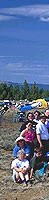
the OSP's attendance runs between 500 and 700 men, women, children
and pets. Our planned 2017 SOLAR ECLIPSE star party, however,
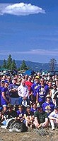
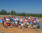
was so large that it was limited to 900 registrants! The picture
above is the 1998 Group Photo, which was six years after we moved
to our current 5000 ft. high site in the Ochoco Mountains of Eastern
Oregon. The 1998 photo attendance was 610, out of which 166 got
out of bed to pose for the annual Group photo. That year the Swayze-built
40 inch Dobsonian Telescope gave eye-popping views of the heavens
to anyone brave enough to ascend the lofty aluminum ladder to
its giant 2" eyepiece; it was a true Stairway to Heaven.... OMSI, Oregon's premier science museum,
helps sponsor the event every year.... The Rose City Astronomers, Oregon's largest club, is also
heavily involved (see more at bottom of page)... I have been the
official Group Photographer since 1989, and all the past years'
photos are available for ordering (brucej@Oregonphotos.com).
2023: We've scheduled
the Star Party for July 18-23! It went well. I'll post the group
photo in due course.
2022: we got
cancelled again, this time to major road construction on the main
access road!
2021: The USFS
cancelled us due to extreme fire danger... 2022 OSP is getting
ready, cross all your fingers! July 26-31, 2002.
2020: We reluctantly
cancelled the 2020 OSP due to CoVid-19 dangers.
2019 Group Photo: all prints and digital prints have been mailed out
(late September). I'll post a version of the photo soon.
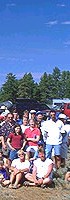
 2018. The year of Climate Change Writ
large. 111 people and 4 dogs
showed up for our 2018 Group Photo. Click image for larger version,
plus a closeup of Chuck and Judy Dethloff and other long-timers
such as Jan Kieski. Look at Bruce's doppelganger in the larger
picture; he is an amazing likeness of Bruce Johnson. All the digital
downloads and prints were sent by Sept. 29th. See you all next
year.
2018. The year of Climate Change Writ
large. 111 people and 4 dogs
showed up for our 2018 Group Photo. Click image for larger version,
plus a closeup of Chuck and Judy Dethloff and other long-timers
such as Jan Kieski. Look at Bruce's doppelganger in the larger
picture; he is an amazing likeness of Bruce Johnson. All the digital
downloads and prints were sent by Sept. 29th. See you all next
year.
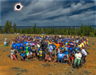 2017. A Total Solar Eclipse
graced the OSP this year!
We had enormous
attendance, 880 souls. Here's
the 2017 Group Photo.
It had 152 persons in it.
2017. A Total Solar Eclipse
graced the OSP this year!
We had enormous
attendance, 880 souls. Here's
the 2017 Group Photo.
It had 152 persons in it.
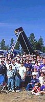
The 2016 Photo
shoot drew 118 persons and
was held under sunny skies and enjoyed moderate temperatures.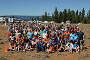 It's the first Group Photo in several
years to be oriented to show the LIGHTNING TREE in the background. The 2016 OSP
as a whole drew close to 590 persons! Click on the picture to see a larger version and additional
pictures from 2016!
It's the first Group Photo in several
years to be oriented to show the LIGHTNING TREE in the background. The 2016 OSP
as a whole drew close to 590 persons! Click on the picture to see a larger version and additional
pictures from 2016!
Click
here for link to group photos
from 2015 far back into the past, all the way to 1988 at Steens
Mountain!
Oregon
Star Party History Section
Panoramas and Binocular
Astronomy!
Here's the promised 360-degree
panorama of the 1999 Oregon Star Party, taken from high atop the
roof of Chuck and Judy's RV. See if you can pick out your campsite
and scope, and those of your friends! Note: recently, I have added
also a Panorama of the site from 2009!
The Mountains Surrounding OSP, pg. 1, Lookout Mountain,
plus two additional pages

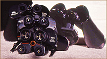
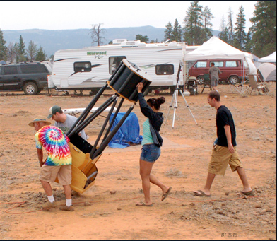
Owning
a big scope can be work! If you know who took this picture, please
let me know so I can give you credit. Was it you, Jan?
 See
a Panorama of this author's (former) astronomy property located
12 miles south of Prineville, Oregon (about
30 air miles southwest of the OSP site).
See
a Panorama of this author's (former) astronomy property located
12 miles south of Prineville, Oregon (about
30 air miles southwest of the OSP site).
April 2008. Click below
for the latest news and developments from Highgate Farm Star Party.
This site is a 100 acre farm on the southern fringe of the Portland
Metro Area that is being considered as a permanent "nearby"
viewing site by RCA.
Go to
the summit of
Mauna Kea, Hawaii,
and witness 200 brave OSP astronomers, and see Jan Kieski up there
for real in 2017!
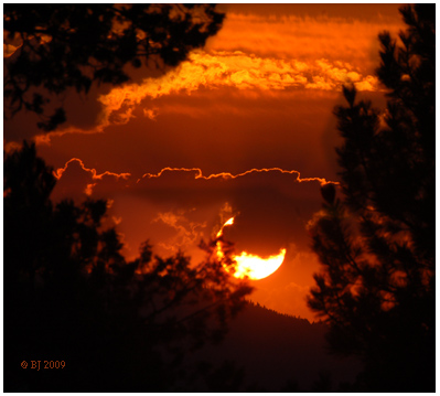
Sunset at OSP 2009, a Thursday.
OSP 2023 will be near new moon Tuesday, July 16th.
See official OSP site below for more information about OSP 2023
**
For further
information please contact the
Oregon
Star party, Inc. The official website:
Mail them at their
snail-mail address: Oregon Star Party
PO Box 1396
Clackamas, Oregon 97015
or e-Mail
them at: OSP
Inc.

Page Last Revised
October 16, 202310/16/2023
Bruce Johnson's
Mileage Log to and from OSP
(Ochoco
Mtns, at Indian Trail Springs (ITS)... Note: Google Earth
maps locate our site as being on "National Forest Develop
Road 800," and also show it as "Fox Reservoir Road"...They
display our altitude as 5,030 feet... They show the road to Indian
Trail Springs as "North Fork Road," but do not label
the spring itself. .. The aerial maps are so good that if we'd
been on-site when the photos were taken, you could have clearly
seen our cars and the bigger scopes!
Note:
click here for description of the
Alternate Route
from Prineville up to OSP)
Olympia,
Washington to OSP site = 426 miles, via Hwy 12 (White Pass) to
Yakima, and
thence along Hwy 97 to Prineville (compare with just 200 miles
from central Portland
to OSP, or to 225 miles from Canby to OSP)
OSP TO
OLYMPIA via the shortest route = 302 miles, which is over Government
Camp and
up I-205 and I-5.
BEND
TO OLYMPIA, via Government Camp, I-205, and I-5 = 266 MILES
(compare to 392 miles taking the route along Hwy 97 to Yakima,
and over White Pass
on Hwy 12)
PRINEVILLE
TO OSP (Indian Trail Springs, "ITS") = 48 miles
PRINEVILLE
TO PORTLAND = 146 MILES (taken from the Highway Dept. road sign
as you
leave Prineville headed toward Madras on Hwy 26)
Add the above figures, which gives 196 miles between OSP and Portland
(but which
side of Portland is this?). Just call it "about 200 miles"
is my vote.
OSP back
to downtown BEND = 88 miles (via the "back way" where
you cut off at Powell
Buttes and come in near the Bend airport, I call this route "the
Alfafa cutoff")
BEND
TO GOVERNMENT CAMP ON MT. HOOD = 106 miles
BEND
TO PORTLAND (via Government Camp, and to the junction of I-84
and I-205) = 156
miles.
BEND
TO OLYMPIA, WA, via Government Camp, I-205, and I-5 = 266 MILES
(compare to
392 miles taking the route through Yakima and along Hwy 97)
BEND
BACK TO EAST SIDE OF PORTLAND (junction of I-84 and I-205) = 156
miles
Olympia
to Goldendale, WA, elev. 1,600 ft = 246 miles. Goldendale is site
of the
Goldendale Observatory
and of Skyview
Acres. (this is
a whole lot further than from Canby to Bend!)
Some
Route Details:
Olympia
to the turnoff to Yakima (I-5 to junction of Hwy 12) = 38 miles
(here the highway sign states it is 140 miles more to Yakima)
Olympia to the small town of Morton at 900 ft. elev. = 70 miles
(compare to Canby to Timberline Lodge is only 73 miles)
Olympia to the turnoff to the road that goes up to the north side
of
Mt. St. Helens (Windy Ridge viewpoint) = 84 miles, and an estimated
25-40 more miles up to the Mtn. itself.
Randle, 900 ft. elev. 88 miles from Olympia
Olympia
to turnoff to the Goat Rocks Wilderness-- turnoff is shortly before
Packwood,
and is labelled to Walupt Lake. Turnoff is 100 miles from Olympia,
and is 1,000 ft
elev. est. another 20 miles to trailheads (therefore at about
120 miles, this is twice
as far way as hiking on Mt. Hood from Canby)
Olympia
to the cute little resort/mountain town of Packwood is about 105
miles, elev.
of Packwood is about 1,200 ft. The road branches left to the southern
entrance of
Mt. Rainier Park about 5 miles east of Packwood (at about 110
miles from Olympia)
Olympia
to White Pass and White Pass Ski Area (see below)
Mileage
Log going east via Hwy 12 and Yakima, Hwy 97, and then up to OSP
site.
Olympia
to White Pass, 124 miles (compare to 63 miles from Canby to Government
Camp)
Olympia
to Yakima, 176 miles (compare to 135 from Canby to Bend via Hwy
22 and Santiam
Pass, or compare to only 90 miles from Canby to Kahneeta!)
Yakima
back to White Pass, only 52 miles (don't they have a great deal
to get up to a good ski area!)
Olympia
to Goldendale, WA, elev. 1,600 ft = 246 miles. Goldendale is site
of the
Goldendale Observatory
and of Skyview
Acres. (this is
a whole lot further than from Canby to Bend!)
PRINEVILLE
TO OSP (Indian Trail Springs, "ITS") = 48 miles
PRINEVILLE
TO PORTLAND = 146 MILES (taken from the Highway Dept. road sign
as you leave Prineville headed toward Madras on Hwy 26)
Add the above, gives 196 miles between OSP and Portland (but which
side of Portland is this?). Just call it "about 200 miles"
is my vote.
OSP BACK
TO downtown BEND = 88 miles (via the "back way" where
you cut off at Powell Buttes and come in near the Bend airport)
BEND TO GOVERNMENT CAMP ON MT. HOOD = 106 miles
BEND TO PORTLAND (Via Government Camp, and to the junction of
I-84 and I-205) = 156 miles
BEND TO OLYMPIA, WA, VIA GOVERNMENT CAMP, I-205, AND I-5 = 266
MILES (compare to 426 miles taking the route through Yakima and
along Hwy 97)
BEND
BACK TO EAST SIDE OF PORTLAND (junction of I-84 and I-205) = 156
miles
OSP BACK
TO OLYMPIA VIA GOVERNMENT CAMP, I-205 AND I-5 = 302 miles.
05/14/2023