 THE MOUNTAINS SURROUNDING OSPTHE MOUNTAINS SURROUNDING OSP
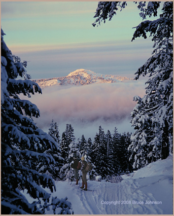
We are standing high on Lookout Mountain during a winter sunset. We are looking at Round Mtn. from Lookout Mtn...My friends and I haven't been doing astronomy, we've been on skiis, enjoying crisp air and powder snows atop the crest of the Ochoco's highest peak, Lookout Mountain, 6,926 feet. In the image to the left, the last rays of sunset linger on Round Mountain, 6785 feet. My two friends pause on their steep descent past the upper mining camp, the old Independent Mine. This and other nearby mines dug out and extracted (with ovens) the rather toxic substance Mercury, aka "Cinnabar."
Why was this peak named "Lookout"
Mountain? Well, fire lookout cabins and towers were in use on
the mountain as early as 1924. See picture of the well-constructed
tower on the summit in 1924; picture is from the collection of
Mike Graham, the longtime fire lookout on nearby Mt. Pisgah. 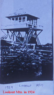 You can still find
a few small remains of an old fire lookout cabin on the summit,
which was destroyed sometime in the 1950s. Perhaps this history
of use led to it being named as it was! Round Mountain also had
fire lookouts on its summit, beginning in the 1930s and extending
all the way to 1972.
You can still find
a few small remains of an old fire lookout cabin on the summit,
which was destroyed sometime in the 1950s. Perhaps this history
of use led to it being named as it was! Round Mountain also had
fire lookouts on its summit, beginning in the 1930s and extending
all the way to 1972.
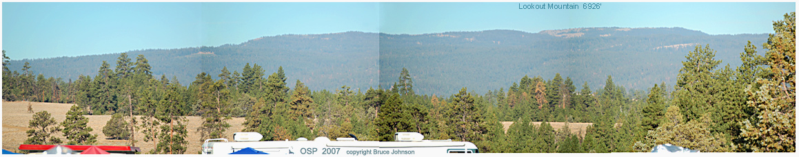
In the picture below, taken from our OSP site 12 miles to the east of Lookout Mtn., you can easily see why the mountain's summit area has some of the best cross-country skiing in Oregon. The summit ridge runs at an altitude of over 6,500 feet for 3 1/2 miles, traversing the space between the aptly-named "North Point" and "South Point." The terrain is ideal, all open, with scattered groves of subalpine trees, and especially broad and open on the south end. If it is windy up on top, you can always find shelter by skiing down into the canyons on the east side; Brush Creek in particular, on the east, offers something close to 1,000 feet of descent before the forest closes in too much to be pleasant, and there are many interesting groves of aspen trees, carved here and there with interesting old signatures and epithets.The two mining camps (upper and lower) are extremely interesting, but in recent years have been officially posted as off-limits. They mined "cinnabar," an ore from which mercury is derived. In the early years of OSP, about 1993, I led a day hiking trip to the mines and then up to the summit for a very fun day.
LOOKOUT MOUNTAIN HELPS THE OSP CLIMATE -- A final note about Lookout Mountain. From my studies, I believe its bulky presence is an important factor in producing the dryness of our Indian Trail site. The high ridge of "Lookout" is about 12 air miles to the west of our 5,000 foot high site. This placement helps produce orographic, descending, drying winds when damp airs from the west rise up over Lookout and descend to OSP. During the drive to OSP from Portland, It is very obvious that a lot of drying takes place as one crosses over the Cascades and descends to Warm Springs, but the similar drying process right near our site itself is often missed. Next time you travel to OSP, pause for a minute on top of the 5630 foot pass between Lookout Mountain and Round Mountain and take note of the relatively dense, dark, moist-looking forests there. Now, as you continue on toward OSP, observe and you will note a marked drying-out and thinning of the forests as you head east along the southern fringe of Big Summit Prarie. By the time you get up to our site, the vegetation itself clearly shows how much drier it is, especially in the lack of fir trees, and the presence of junipers, and even groves of mountain mahogany trees (a true desert tree that is common in all the desert ranges of Nevada).
The summit plateaus of Lookout Mountain would potentially provide a feast of high-altitude observing sites for fairly large groups of people, and there is even a spring, a source of water, right up near the summit--- HOWEVER, the entire area is blocked to vehicle access due to being within the vast Lookout Mountain Roadless Area, and no change to that status is being considered by the Ochoco National Forest.
PICTURE FOR SALE: In addition to selling custom prints of all the OSP Group Photos from past years, I am also going to offer selected other OSP-related scenes. The image above is an example. If you've enjoyed looking west from our site across that great vista of pine trees toward Lookout Mountain, then you might want that on your office wall. You can purchase the above Lookout Mountain panorama in a high-resolution version printed on 10x15 paper (image itself is 15 inches long, and the height is considerably less). Price: $19.00 plus postage. Contact me. (brucej@oregonphotos.com)
a 360 degree panorama of our site and the mountains around it (from 1999 OSP)
"Campers of All Persuasions, a Photo Essay about the Variety of Ways We Make Our Homes At The Oregon Star Party." Click for the first images from that photo essay.
Also: more on the mountains surrounding OSP-- Mt. Pisgah, Round Mountain, and other locations such as the OSP swimming hole at Upper Falls, and also coverage of the alternate route up to OSP, the one going through the town of Mitchell.