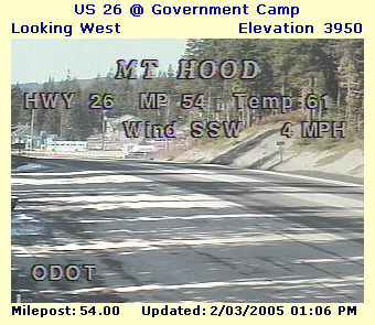
Your eyes aren't fooling you-- yes, You are on the crest of the Cascade Mountains on February 3, 2005, yes, it really is 61 degrees, and that snowless look is for real! ---there are zero inches of snow on the ground!
In a typical winter, by February the ground would be buried by 50 to 100 inch-deep snow at this elevation level, and 2,000 feet higher, at 6,000 feet, a typical snowpack would be smothering everything 130 to 200 inches deep....But on February 3, 2005, the snow depth even at 6,000 feet was only 25 inches (see image next page). This rates as an extreme snow drought.... Click here to read about the winter of 1976-77, probably the worst snow drought to hit Oregon/Washington in the past 100 years.
Background: Oregon's reputation includes stunning ten to twenty foot deep snows that pile up each winter in its Cascade Mountains (a volcanic range which runs the entire N-S length of the State).... Skiers count on the fact that the only reliable summertime skiing outside of Alaska thrives on Mt. Hood, on the higher reaches of Mt. Hood's south side (on the 8,000 foot Palmer Ice Field above Timberline Lodge)..... Many high-powered racing and training camps know this. It's very normal for Timberline Lodge on Mt. Hood to have some of the Nation's deepest snows, and they don't melt off even at the 6,000 ft. high Lodge until sometime in June, with persistent snow patches and snow fields to be found all summer.
Go to page bottom for more details on the snow drought in the Oregon and Washington mountains. The official Weather Service report of February 1st. noted "snowpack in the North Oregon and South Washington Cascades is only 19% of normal and only comparable to the meager snowpacks in the winters of 1976-1977 and 1980-1981."... Note: as of March 15, there has been not a single major snow in the Cascades since February 1st, and the Snow Drought continues unabated! The end of March offical Dept. of Agriculture Snow Survey showed only 23% of normal snow/moisture on the snow course at Timberline Lodge (in the Northern Cascades).
The historic small town of Government Camp tops Oregon's most-travelled east-to-west mountain pass...... On February 3, 2005 we see the town basking in 61 degree heat with zero inches of snow, residents enjoying yet another in a string of warm, sunny days....yet historically such conditions are ASTOUNDING.
The nasty fact is that all over Oregon, the last few days of January and first ten days of February mark the period of the winter when nearly all of Oregon's ALL-TIME COLD RECORDS have been set! Eg. Salem's second all-time lowest "score" of 10 below zero was set January 31st, 1950, and Portland's all-time record of 3 below zero was set on February 2nd. The all-time coldest Oregon has ever been was 54 below zero, recorded at Ukiah on Feb. 9, 1933, and again at Seneca on Feb. 10, 1933. In January 1950, the entire Willamette Valley had severe snow and even blizzard conditions for most of the month, and then ended the frigid spell by setting all-time record coldest records. When one compares the sunny picture above to 1950s arctic conditions, one wonders, "IS THIS FINALLY THE EVIDENCE WE NEED OF GLOBAL WARMING? "
Check out Crater Lake's Amazing State snowfall records!
It's also true that High Cascade snow depths can pile up to over 300 inches deep, even after the official start of Spring, eg. in April or even May (that's over 25 feet deep). The last season such record snowpacks occurred was winter 1998-1999. The April 10th ski report from Timberline Lodge described luscious powder snow conditions at 22 degrees, 6 inches new, and 307 inch base total.... And the May 8th report sounded like mid-winter with 19 degrees, 4 inches of new, and 302 inches on the ground! Such monster snowpacks will choke the high hiking trails until mid-to-late July! (eg. see the 7,010 PCT crossing near Mt. Jefferson)
Winter 1976-77 suffered a severe snow drought, perhaps the most severe in the past 100 years. In mid-January 1977, I was able to drive a passenger car all the way up to 6000 feet on the mountain's NE side, to Cloud Cap Inn, and then hike to well over 7,000 feet on the Timberline Trail, mostly walking on frozen-solid pumice, but very little snow. The road to Cloud Cap is not plowed in the winter, and is not normally free of snow until sometime in June! During this same snowless winter, the State of Washington reported that three of its highest mountain passes remained so snowfree that they were open all winter (North Cascades Pass, Chinook Pass, and Cayuse Pass (all three normally closing each winter between Oct.15-Nov15 and staying closed until late May or even June)... .... The winter of 1980-81 was also marked by a serious snow drought..... It seems assured that Winter 2004-05 will be joining the record books (see page bottom). And 2015 is another year with a major snow drought, as of February 12.... both Government Pass and the Santiam Pass are essentially bare of snow; up in Washington State, the White Pass and its ski area are crying hard, with a meager ten inches of snow at the base level. Is this Global Warming?
February 1, 2005 snow depths: Timberline Lodge is quoted as having 55 inches on the ground, whereas its long-term average is 130 inches on Feb. 1st, with a record maximum of 230 inches on the ground in 2002 (later that year the depth hit over 300 inches!)...... The station with the deepest snow depth on Feb. 1st. is Paradise Lodge on Mt. Rainier with 58 inches, and a normal of 144 inches-- Paradise holds a snowfall record of 1,000 inches in a single season-- its deepest recorded Feb. 1 depth was 264 inches in 1972...... Mt. Hood Meadows Ski Area had only 30 inches snow depth, with its normal being 110 inches, and maximum of 187 inches in 1974...... At a lower elevation, we see pass levels such as Washington's Snoqualmie Pass reporting only 26 inches, against a normal of 87 inches, and a record value of 168 inches in 1949!.... And of course Government Camp in Oregon, as seen at the top of this page, had melted down to bare ground by early February!.... The only snow drought more severe was the drought of 1976-1977, when, for example, Paradise Lodge reported only 24 inches on the ground--- of course, Snow Drought 2004-2005 may overtake '76-77.....Update, March 12: the Snow Drought continues to worsen, and is showing every sign of moving into First Place in the Snow Drought category! I will update this as new data becomes available.
March 15, 2005 Update: this sad morning 20 inches of snow was all that the Oregon State Police would credit Timberline Lodge with in its morning road report....Timberline's climatic normal for March 1 is snow 142 inches deep, while March 1, 2004 had 195 inches on the ground!.....Statewide, the rain and snow drought continues full bore since the February 1 measurements..... People everywhere are becoming quite alarmed. A good example is Salem, which is Oregon's capital city. The March 15th precipitation data was as follows: the entire first half of March had had only 0.02 iches of rain! Since January 1st there had been only 1.94 inches of rain as compared to the long-term average of 13.16 iches. The winter's precipitation (Oct 1st. to March 15th) had been only 11.27 inches, as compared to the average of nearly 30 inches!
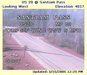
A very unusual spell of warm, dry, sunny weather began about February 10th, and lasted over a month, until about March 14th! Additionally, the lack of rain and snow has co-existed with temperatures much above normal, eg. five record-setting days in a row in Portland, culminating with 75 degrees on March 11th.... To see how askew things were, all you had to do was drive around the area on an early March weekend, and everywhere you gawked at folks in their shorts and t-shirts working in their yards... one was left wondering, "Is this even Oregon anymore?".... Below is an image of Santiam Pass, nearly 5000 ft. high in the Central Cascades, and normally a snow-blasted obstacle to travellers. By mid-March, snows are usually 80-120 inches deep on Santiam Pass, with snow falling most days of the month.....but this year, well, let the picture do the talking!
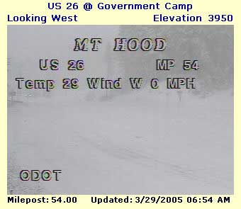
Oregon's snow and rain drought abruptly ended with a brief shot of rain on March 16th; nevertheless, by the 25th, Portland was still dangerously below normal for the month of March, with well under one inch of rain for the entire month (0.89")...... But then on March 26 that all changed BIG TIME, with deluges of rain in the valleys and heavy snowfall in the Cascades... By month's end, Portland's monthly rainfall total had risen to nearly 4 inches, actually above normal for the month! Meanwhile, in the higher Cascades, Timberline Lodge had increased its snowpack from 20 inches deep, to well over 70 inches deep..... Still far below normal, but at least it seemed clear that more normal (eg. cloudy, wet and cool) weather conditions would prevail for Oregon's Springtime. Many Oregonians' hopes rose that major drought disasters could be avoided this summer..... The picture below shows 4,000 ft. Government Camp on Mt. Hood near the end of March, looking normal, but appearances are deceiving-- despite the snowy appearance, the snow was only 3 inches deep!
Updates, April 19, May 23, and July 13 --- as I predicted, the dry, sunny days of early March are long gone...April: the month of April was terribly cloudy, with zero "clear" days and only 3 days even rated as "partly cloudy."....May: the month was like April, with May 1-22 featuring more of the same gloom, every day May 1-22 rated "cloudy" by the Portland Weather Service.. ... In fact, on May 22 the last clear day was 69 days previously (March 14th)......and in the period March 19-May 23 (63 days), there were only seven days not reporting any rain (90% of days have had rain)....The 75 degree warmth recorded on March 11th still had not been equalled as of May 22nd.... Finally, in the high Cascades, the Government Camp scene in the picture above came and went a few times during early April, but by April 19 the snow depth had returned to what was dismally common for Winter 2004-2005, a big, fat ZERO inches, which remained true as of May 22.
July 13 Update, now it is Mid-July in Oregon
Gloomy Spring 2005 is competing
very well with Gloomy
Spring 2003.....
May 2005's gloomy, cool weather suddenly turned to RAGING HEAT for a few days late in the month, then went decisively
back to more gloomy coolness, which continues as of July 13 (see
July 11 satellite image below), with a few intermissions into
warmer days, but with skies still rated as only partly to mostly
cloudy....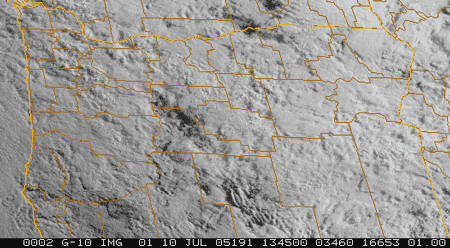 Although
July 4th itself rated as a clear day, it has been the only
clear day so far in either June or July in Portland, a dismal
record indeed!.... As of July 13, there are a few more "mostly
cloudy" days forecast until FINALLY the forecasters dare
to predict that Portland's normal July weather will start to take
hold about July 17 ("Normal" would be numerous consecutive
mostly clear days, zero precipitation, and with highs in the 80-90
range)
Although
July 4th itself rated as a clear day, it has been the only
clear day so far in either June or July in Portland, a dismal
record indeed!.... As of July 13, there are a few more "mostly
cloudy" days forecast until FINALLY the forecasters dare
to predict that Portland's normal July weather will start to take
hold about July 17 ("Normal" would be numerous consecutive
mostly clear days, zero precipitation, and with highs in the 80-90
range)
July 16 Update: finally, Portland officially posted a second clear day since June 1st. This was July 14th, which squeaked into the "clear" category with a cloudiness rating of 3 out of 10. ... The Forecast is still optimistic that July 17th will be clear and somewhat hot, with a streak of true summer days predicted to follow. Dare we hope for Summer?
( Note: July is supposedly Portland's hottest and clearest month according to long term weather records).....The much-feared 2004-2005 Drought has certainly been much-relieved by the very cloudy and cool weather we have experienced ever since late March.
95 degree HEAT WAVE--- on May 22, 2005 the high was a chilly 64 and cloudy, but only five days later, on May 27, the high was a blistering 95 at the Portland Airport, and people, plants and animals all suffered in the unaccustomed heat.... Then, a mere two days after that scorching day, the day's high was back down to 64, and temperatures have stayed at mostly subnormal levels ever since, under cloudy skies; in fact, June ended with ZERO clear days!* On the plus side, the number of rainy days lessened, and temperatures have remained cool/mild for those people who don't like summer heat; in fact, as of July 13, the 95 degrees recorded on May 27 still stands as the year's highest to date by a full 11 degrees-- amazing because it is now nearly mid-July! ---June 27 was especially dreary and un-summery, with a nasty, constant drizzle the entire day and afternoon high temperatures just barely over 60 degrees! July 8 was in some ways an even nastier day, with a high of only 64, a low of 60, and off and on rain most of the day! Note, August 3, 2005--- as of today, this May 27 mark of 95 degrees STILL STANDS AS THE YEAR'S HIGHEST TEMPERATURE! October 20 update: May 27's mark was exceeded by one degree on August 4th. As of late October, the highest temperature for 2005 proved to be the 96 degrees recorded on August 4th..... Summer 2005 was very dry, but had no really extreme or protracted heat waves; in fact, if a "heat wave" is defined as three or more days with highs of 90 or above, there were only two heat waves during 2005, both during August, and both were only three days long! During the hottest of the two, the average daily high was 93. Click for Summer of 2005 Recap.
* People email to tell me that their May/June was not nearly as bad as what I report above. The truth is that these gloomy statistics are the official readings at the National Weather Service office at the Portland airport. So, if one lives in the main part of Portland, the statistics hold true. However, at locations further south, eg. Salem, Albany, Eugene, somewhat more clear skies occur. This is due to a regional pattern wherein marine air invasions of "morning low clouds" linger more persistently in the Portland area. For instance, the average cloudiness in June 2005 in Portland was 8 out of 10, whereas in Salem it was better, at 6 out of 10.