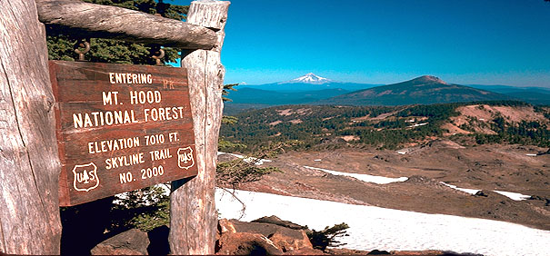
The Oregon Skyline Trail! Here is one of its highest crossings, now redesignated
the Park Butte Pacific Crest Trail crossing. Interestingly, however,
a relevant photo (2005) taken by a friend showed this historic
sign still in place, looking unchanged from when I myself had
photographed it in 1971.... Hurrah!......Mt. Hood, Oregon's highest
peak, looms in the background. In the near distance is Olallie
Butte (olallie is a Chinook word for "berry")....If
you turn around at this spot and look south, there is a very near
and impressive view of the north side of Mt.
Jefferson.... Expect to be hiking portions of this trail crossing
on snow even at the end of August during most years!
Note the peak of Mt. Rainier to the left
of Mt. Hood. It'sseen in the distant background, well over 100
air miles away (it's the dim white thing being pointed at by the
hemlock frond).
Highest Point of PCT trail in Oregon!
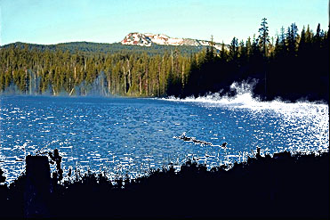
Above you see
Maidu Lake, alive with morning mists... It is the source of the
North Umpqua River, and for unknown reasons carries the name of
a California Indian tribe. Maidu Lake is remote by anyone's standards,
even in the 21st Century. It is poised on the Cascade divide between
Western Oregon and Eastern Oregon, lying at just under 6,000 feet....
Across the lake rises 8,000 foot high Tipsoo Peak (a Chinook word
for "grassy"). Beyond Tipsoo lurks the dark spire of
Mt. Thielson.
The PCT crawls
over the left shoulder of Tipsoo, reaching a lofty 7,570 ft. In
the picture above, the PCT is located just barely to the left
of where the trees end on the left shoulder of the peak.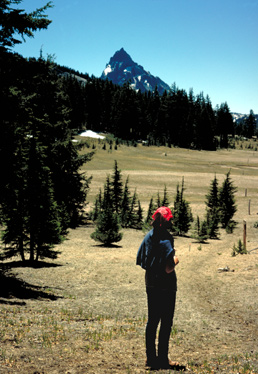 This location is
best accessed from Miller Lake, where the dirt road ends. The
hike toward Maidu can also take you near 7,271' Red Cone, which
is a fun Class 5 scramble that ought to be roped for anyone inexperienced.
The picture to the left shows you the view southward once you
reach the shoulder of Tipsoo and start down the other side. Mt.
Thielson dominates the view!
This location is
best accessed from Miller Lake, where the dirt road ends. The
hike toward Maidu can also take you near 7,271' Red Cone, which
is a fun Class 5 scramble that ought to be roped for anyone inexperienced.
The picture to the left shows you the view southward once you
reach the shoulder of Tipsoo and start down the other side. Mt.
Thielson dominates the view!
The shoulder
of Tipsoo is the Highest Point you can reach in Oregon on the PCT.... From this shoulder, the
view south will wow you with an awesome view of the dark cliffs
of the north
wall of Mt. Thielson....
From where this
hiker is standing, if you climb to the summit of nearby Howlock
Mountain, a marvelous panorama will unfold. This summit is only
about 800 feet higher, and about 3 miles to the SSE. (click
to see this panorama).
At page
bottom you will find a very interesting tale about famous Scottish botantist
David Douglas
and his 1826 visit to the canyons just west of Maidu Lake.
Return
to Oregon Photos Main page

Page
Last Revised 2/18/2024
Prelude:
David
Douglas, Pioneer Botanist and Oregon Explorer
copyright
2008-2020 by Bruce B. Johnson, all rights reserved
He was born 1799
in Scotland, and immortalized in America by having the Douglas
Fir tree named after him. So what was the famous David Douglas
doing in late October, 1826, nearly two hundred miles from the
nearest Fort, many miles away from his companions, and facing
down eight Indians underneath some very big pine trees? By Douglas'
own account, his distinquished career nearly ended there at the
tender age of 27. *
Here's background
before hearing of Douglas' adventure.
Oregon of 1826
was decades away from Statehood. It had no towns or cities. No
roads ran through it. There were no phone or telegraph lines.
Train tracks were yet to be laid. The future Oregon was ruled
by the 1818 Treaty of Joint Occupation between America and England.
The entire region was wall-to-wall wilderness with a few scattered
forts and fur company trading posts--- and no fortified locations
within a two week march of Douglas' small band of explorers that
October. Oregon's first major wave of settlers were still twenty
years in the future and there was nothing called the Oregon Trail
in existence.
Outside the walls
of the few forts and trading posts, the many bands and tribes
of Indians had only heard rumors and tales of the White Man. In
the case of Douglas' trip to the Umpqua region, the rumors were
likely to have been dark ones. In the late Fall of 1818, the Umpqua
region had been scarred by violence, when a white party of 60
men from the North West Fur Company had killed 14 Indians near
the present site of Yoncalla. As no White deaths are noted in
the account, one must suspect that the event was somewhat of a
massacre. Thus in 1826 an encounter with any band of Indians in
the Umpqua region was an entirely uncertain proposition which
might end in a nasty death. And family and friends back in Civilization
in New York or London would hear only, "He left Fort Vancouver
on (date) and was never heard from again."
Modern Freeway
travelers on Oregon's largest freeway, Interstate 5, will marvel
at the clear waters of the Umpqua River as they pass through the
town of Roseburg, but the journey up the River from there in Douglas'
day was daunting indeed-- 106 miles of rugged travel along game
and Indian trails through dense forests. If Douglas had tried
to reach Maidu Lake in the headwaters, it would have taken him
at least a week of difficult travel.
"SUGAR PINE, A BOTANICAL
HORROR STORY"
In August 1825,
somewhere in the vicinity of present-day Portland, the ever-inquisitive
Douglas had poked through the contents of an Indian's smoking
pouch. His attention had been grabbed by some large seeds. To
a botanist of Douglas' talents, the seeds spoke of a probable
new tree species. The owner of the pouch was interrogated,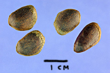 and described a distant
river to the south in whose upper reaches grew a giant pine that
sounded like a new and wonderous species. Douglas already had
accumulated an impressive list of "firsts" in the botanical
world, and resolved to track down this mystery tree, which he
was sure was a pine. Seed Image credit: Steve Hurst @ USDA-NRCS
PLANTS Database
and described a distant
river to the south in whose upper reaches grew a giant pine that
sounded like a new and wonderous species. Douglas already had
accumulated an impressive list of "firsts" in the botanical
world, and resolved to track down this mystery tree, which he
was sure was a pine. Seed Image credit: Steve Hurst @ USDA-NRCS
PLANTS Database
The following
year (1826) Douglas spent the summer travelling up and down the
Columbia River east of the Cascades, and collected plants all
the way up into the Blue Mountains of Eastern Oregon. But the
mystery seeds in the smoking pouch remained on his mind, and in
the early Fall of 1826 he found his opportunity when he visited
the newly-dedicated Fort Vancouver. Here he found a large party
of Hudson Bay Company personnel who were headed south into the
region where Douglas believed his pine trees were to be found.
Dr. John McLoughlin
was the new Chief Factor of the Fort. McLoughlin had Scottish
roots on his mother's side, and had taken his medical training
at the University of Edinburgh, so it wasn't surprising that Douglas
found himself gifted with a prize horse. Dr. McLoughlin was destined
to loom large in the history of the West, later being officially
honored as "The Father of Oregon."
Douglas' travelling
party numbered nearly 20. Their route was pointed into the present
area of Roseburg, 180 miles to the south.
By mid-October
Douglas and his several white and Indian companions reached the
Umpqua River, most likely where Elk Creek joins the river. This
location is roughly halfway between the Pacific Ocean and the
present-day site of Roseburg. They set up a base camp there. It
had been a long and arduous trip, and food had often been short,
with many hungry days due to rather erratic hunting success. It
was wild, primeval country, but exciting, and the party had examined
many giant-sized tree specimens, and also been excited by large
wildlife such as elk and grizzly bears.
Finally, on the
morning of October 23rd, 1826, Douglas' long-sought search for
the mystery pine moved into high gear. He left his companions
and headed upriver in the company of a single Indian guide that
he'd just met, supported by just two horses, one of them Dr. McLoughlin's.
After two days
of very rugged and tiring travel the two men had made only about
22 miles and stopped for the night in very heavy rain. They were
far east of the Umpqua River in hilly upland country. He writes,
"Last night was one of the most dreadful I ever witnessed.
The rain, driven by the violence of the wind, rendered it impossible
for me to keep any fire, and to add misery to my affliction my
tent was blown down at midnight, when I lay among Pteris aquilina
rolled in my wet blanket and tent till morning. Sleep of course
was not to be had. Every ten or fitteen minutes immense trees
falling producing a crash as if the earth was cleaving asunder,
which with the thunder peal on peal before the echo of the former
died away, and the lightning in zigzag and forked flashes had
on my mind a sensation more than I can ever give vent to; and
more so, when I think of the place and my circumstances....before
sunrise clear, but cold...completely drenched...still shivering....I
was seized with a severe headache and pain in the stomach, with
giddiness and dimness of sight; having no medicine except a few
grains of calomel... I could not think of taking that and therefore
threw myself into a violent perspiration and in the evening felt
a little relieved."
The next day
he travelled 18 more miles, this time headed south toward a likely
ridge that he felt might be good habitat for a pine. Along the
way, he crossed back to south side of the Umpqua River and set
up camp several miles past the River. On the morning of October
26th, he left camp to the care of his Indian guide and went on
alone. After walking perhaps another 3-5 miles he had a tense
encounter with an armed Indian who suddenly appeared. After apparently
gaining this man's trust, the fellow was shown a quick tree sketch
and agreed to lead Douglas to the pine trees he sought.
This led to another
two or three hours of hiking in the mountainous terrain. Suddenly
Douglas found himelf among giant pine trees that fit the description
he'd dreamed of for over a year. In great excitement he carefully
measured a very large specimen that was a fallen tree. It was
over 57 feet in circumference and its trunk revealed that it had
stood 215 feet tall (if alive today, this tree would be the largest
of its kind in the Northwest).

Image: Sugar pine bark is much-furrowed
and bears a distinct resemblance to Ponderosa pine bark, but the
crown of the mature Sugar Pine is very distinctive and hard to
confuse with anything else by virtue of its having prominent branches
growing far out at nearly right angles to the trunk. Ponderosa
pines, aka Yellow Pines, are much more numerous and widely-distributed
than Sugar Pines.
Standing there
in the woods with his newly-found species, Douglas now faced a
serious problem as a botanist; he really needed seeds and cones
to take back to Civilization, without such physical proof his
science would be very incomplete, and could even be dismissed.
The live trees around him were completely unclimbable and he had
no equipment to attempt to cut one down! So he had what one might
call a "brillant idea," and began to use his rifle to
shoot cones down.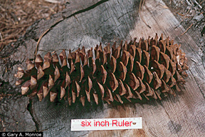 Soon he had three of the giant-size cones, but unfortunately also
eight rather hostile Indians, who had been drawn by the sounds
of his gunshots (remember, these Indians might never before have
seen a White Man, and probably had only heard rumors of what guns
were). Douglas wrote tersely in his Journal, "They were all
painted with red earth, armed with bows, arrows, spears of bone,
and flint knives, and seemed to me anything but friendly."
From the Native Americans' point of view, here was a brazen white
man daring to come among them and poach the tasty seeds of their
favorite pine! For a brief time Douglas believed he had calmed
his suspicious visitors with a smoke, but then "perceived
one string his bow and another sharpen his flint knife....which
gave me ample testimony of their inclination. To save myself I
could not do by flight, and without any hesitation I went backwards
six paces and cocked my gun, and then pulled from my belt one
of my pistols, which I held in my left hand. I was determined
to fight for Life. ....I stood eight or ten minutes looking at
them and they at me without a word passing." This potentially
fatal standoff ended with another tobacco offer, followed by Douglas
sending the Indians off to fetch him some cones..."and as
soon as out of sight I picked up my three cones and a few twigs,
and made a quick retreat to my camp." (which was a number
of miles away)...which I gained at dusk. The Indian who had been
his temporary guide that day "I sent off, lest he should
betray me." Then followed what was certainly a tense night,
alone in deep wilderness except for the company of his first Indian
guide, with whom he could barely converse about what had just
happened, or what to do about it. Image credit: Gary A. Monroe
@ USDA-NRCS PLANTS Database
Soon he had three of the giant-size cones, but unfortunately also
eight rather hostile Indians, who had been drawn by the sounds
of his gunshots (remember, these Indians might never before have
seen a White Man, and probably had only heard rumors of what guns
were). Douglas wrote tersely in his Journal, "They were all
painted with red earth, armed with bows, arrows, spears of bone,
and flint knives, and seemed to me anything but friendly."
From the Native Americans' point of view, here was a brazen white
man daring to come among them and poach the tasty seeds of their
favorite pine! For a brief time Douglas believed he had calmed
his suspicious visitors with a smoke, but then "perceived
one string his bow and another sharpen his flint knife....which
gave me ample testimony of their inclination. To save myself I
could not do by flight, and without any hesitation I went backwards
six paces and cocked my gun, and then pulled from my belt one
of my pistols, which I held in my left hand. I was determined
to fight for Life. ....I stood eight or ten minutes looking at
them and they at me without a word passing." This potentially
fatal standoff ended with another tobacco offer, followed by Douglas
sending the Indians off to fetch him some cones..."and as
soon as out of sight I picked up my three cones and a few twigs,
and made a quick retreat to my camp." (which was a number
of miles away)...which I gained at dusk. The Indian who had been
his temporary guide that day "I sent off, lest he should
betray me." Then followed what was certainly a tense night,
alone in deep wilderness except for the company of his first Indian
guide, with whom he could barely converse about what had just
happened, or what to do about it. Image credit: Gary A. Monroe
@ USDA-NRCS PLANTS Database
In the pre-dawn
darkness, his Indian guide burst into camp "in great terror
and hurry, and uttered a shriek. I sprang to my feet, thinking
the Indians I saw yesterday had found me out, but by gesture I
learned he had been attacked by a large grizzly bear." The
tale continues after daylight, when Douglas had followed the bear
on horseback and discovered that it was a mother with two cubs,
"I levelled my gun at the heart of the mother [bear]."
After he has killed the mother bear, and also has shot one of
her two cubs, he makes payment to his guide, "with the carcase
of the young one I paid my last guide, who seemed to lay great
store by it."
Adding to Douglas'
trials as he attempted to escape downriver, the weather was horrible.
He notes succintly, "Heavy rain throughout the day,"
and the next two days of travel are no better, "both days
very rainy, and having very little clothing and impossible to
keep myself dry night or day obliged me to make all the exertion
in my power to reach the camp near the sea...[my horses] being
greatly fatigued and the road [route] daily getting worse by the
continual rain...Boiled the last of my rice for supper, without
salt or anything else, and had but a scanty meal."
The third day
of Douglas' escape featured more stress, "when one of the
poor horses [the one given by Dr. John McLoughlin] fell and descended
the whole height [of a large woody hill] over the dead wood and
large stones, and would have been inevitably dashed to pieces
in the river had he not been arrested by being wedged fast between
two large trees that were lying across the hill. I immediately
tied his legs and head close to the ground to keep him from westling
and with my hatchet I cut the lower tree and relieved him, [the
horse] having received but little injury."
Arriving back
at base camp finally, Douglas found that all his white companions
were away on various journeys, leaving only two Indian companions,
from whom he learned the very bad news that the local Indians
"had been troublesome." That night the exhausted Douglas
first coped with "very heavy rain during the night.' Worse
by far, he notes, "last night around ten o'clock several
Indians were seen round our camp all armed, and of course instead
of sleep we had to make a large fire, leave camp a little distance,
and hide in the grass to watch. An hour and a half before day[light]
a party of fifteen passed us, crashing among the grass toward
our fire; we immediately fired blank shot and scared them....returned
to camp....I had not a single bit of dry clothing and it [was]
still raining." In the same region, just two years later,
an Indian-laid attack was highly successful, when Jedediah Smith's
party of 19 men was ambushed by "Lower Umpqua" Indians
and only four of the men escaped alive to report the sad tale
weeks later at Fort Vancouver.
For Douglas'
endangered party, the following day featured "heavy showers...cold
and raw." At noon an Indian who had been a guide for some
of Douglas' companions returned, which might have been a good
sign, but for the fact that the fellow "brought on his back
one of their coats and had in his possession some of the hunting
implements, and looked altogether very suspicious; for the present,
as we do not understand their language, we pay no attention; perhaps
he has stolen and not murdered them.... I find myself greatly
fatigued and very weak."
The next day
was November 1st, and finally matters began to improve somewhat
when his white companion and friend "Baptist Mackay"
returned from the Oregon Coast, "telling me he hardly ever
experienced such bad weather; he had not a dry day. We felt a
little relieved to think our small party getting strong."
November 2nd,
1826 marked the end of Douglas' major trials when Mackay shot
"a fine large doe" for food and around 4pm thirteen
of their companions arrived in five canoes. "I find this
evening pass away agreeably [compared to] the eleven preceding
[evenings] ... to have a visage of one's own colour is pleasing;
each [person] gave an account of the chase in turn. I find myself
[to] stand high among them as a marksman and passable as a hunter."
On November 7th, Douglas and two Hudson Bay Company employees
left the Umpqua for the long journey back to Fort Vancouver.
In a reflective
moment, Douglas writes, "When my people in England are made
acquainted with my travels, they may perhaps think I have told
them nothing but my miseries. That may be very correct, but I
now know that such objects as I am in quest of are not obtained
without a share of labour, anxiety of mind, and sometimes risk
of personal safety."
POSTSCRIPT: In
the classic Bible of Western trees, none other than George Sudworth
himself unabashedly states that the Sugar Pine is "the largest
and most magnificent of the Pacific white pines, if not all the
timber pines of the (Northwest) region." ('Forest Trees of
the Pacific Slope," 1908, and reprinted many times since).
John Muir was also a great admirer of the Sugar Pine, calling
it the "Queen of the Sierras," and with good reason
because the Oregon mountains really mark only the northern edge
of the Sugar Pine's range, with the best and most extensive forests
of them found in the central Sierra Nevada mountains, the region
where John Muir most loved to explore.
Faded into history
now is Na'tele, the orginal Umpqua Indian name for the
Sugar Pine. Pinus lambertiana Dougl. now commemorates David
Douglas' discovery for all time.
In modern times,
the Sugar Pine has been so highly valued as a timber tree that
it is now classed in a low-level of risk category as an endangered
species, due to both extensive logging and to disease attacks.
Footnote: The
Tragic End of David Douglas.
The life of a
frontier botanist was indeed hazardous. Just eight years after
escaping death while identifying the Sugar Pine, Douglas met his
end at the age of only 35 while on a botany trip on the Big Island
of Hawaii. The circumstances of his violent death were investigated
for over forty years, but the most likely scenario was that he
was again travelling alone, and had the bad luck to display his
money pouch to a known felon, and was murdered for his money.
He is buried on the island of Oahu in Honolulu, certainly thousands
of miles from the country of his birth, and even thousands of
miles distant from the frontier United States in which he had
made so many discoveries.
Note: in pre-White
man times, the traditional "trade" language of the many
widely-scattered bands and tribes of the Northwest was Chinook.
It was a very simple language replete with much signing and gesticulation,
and was absolutely essential to the region's economy becasuse
the hundred-or-so Native languages were largely mutually incomprehensible.
Thus, despite the remoteness of the Roseburg/Umpqua area from
the main trade corridor along the Columbia River, it was likely
that at least a some of the Indians in the story above were able
to communicate with the Douglas party's Chinook interpreter, Mr.
Michel Laframboise.
Copyright 2008-2024
by Bruce B. Johnson, all rights reserved.
Additional Information:
Where were those
Sugar pines that Douglas found? My own educated guess was formed
by carefully tracing his self-described route on topographic maps.
I believe his pines were found somewhere just east of the present-day
town of Roseburg. A likely location was high on Lane Moutain's
northern slopes. This mountain is 3,468 feet high and could have
had good habitat for Sugar pines in Douglas' day. Climatic note
of relevance: the Northwest's climate was much cooler in the early
1800s and Sugar Pines could have comfortably grown in locations
that presently are too hot/dry. Please read my discussion of the
LIA (Little Ice Age) for details.
WHERE TO SEE
SUGAR PINE IN OREGON: quoted from the National Park Service at
Crater Lake National Park: "There are fine groups of Sugar
pine at many points along the road from Medford to the park. One
tree especially that may be seen about 8 miles north of Prospect
is nearly 8 feet in diameter and contains 25,000 feet, board measure,
of timber. [Coming into the Park via the southeast entrance] while
ascending Annie Creek, the traveler who does not leave the road
will fail to see the finest Sugar pines. It is well worth while
to wander out into the forest away from the stream, and there
find the tree at its best, towering among the yellow (Ponderosa)
pines and firs and scattering its great cones among the ceanothus
and chinquapin brush at its feet."
Sugarpine Mountain,
6,400 feet,
lies 22 air miles southeast of Maidu Lake, in the dry forests
east of the Cascade Mountains, in the Winema National Forest,
Chemult Ranger District. The lookout tower on its summit was staffed
by my very own brother Roger Johnson back in the early 1970s,
shortly after the mountain got it first modern lookout structure,
which was in 1970--my brother's home was a 20 foot steel, live-in
tower that formerly was the Fort Klamath Lookout. For a picture,
here is a link: http://www.firelookout.com/or/sugarpinemtn.html
Sugar Pine cones
are justly famous in the tourist trade because they are the longest
cones of any North American tree-- up to 26 inches long! Go to
this site to see a great picture of huge sugar pine cones being
held in a person's hands, which will give you a better idea of
just how huge these cones really are: http://www.backyardnature.net/sierras/pines.htm
The tree itself:
Gary A. Monroe @ USDA-NRCS PLANTS Database
The needles:
Susan McDougall @ USDA-NRCS PLANTS Database