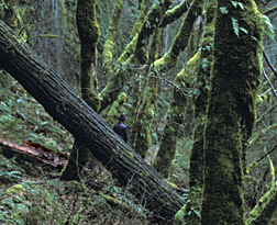
Gloom
hits Portland area hard in first half of 2003
New Records Set!
"46 out of 49,"
"66 out of 70," and "1 out of 97"
2003 Gloom vs. Spring
2004 Global Warming?
After a nice February 2003 that
created high hopes for a pleasant March and April, the weather
gods turned mean and clobbered Portlanders in Spring 2003 with
an endless gloom that set at least two new records. Then even
Summer 2003 continued to dabble around with the gloom. (Spring
2004 totally reversed this trend, see page bottom)
February 2003 had a very uncharacteristic SEVEN clear days, temperatures
averaging slightly above normal, and wonderful spring bulbs and
budding foliage began popping out all over the place! .But on February 28th, that all changed, and March
turned miserable with the "Oregon Duck" thing for which
Western Oregon is so infamous. Sufferers of seasonal affective
disorder (SAD) sunk deeper and deeper into despair as Spring 2003
developed.
 It
began to rain on Feb. 28th, and did not let up until 28 days later,
in the process setting a new March record of 27 straight
days with rain..... Surprisingly, the 28 days with measureable
rain from Feb. 28 to March 27 only placed tenth in the long-term
annual records for "most consecutive days with measureable
rain." Grimly, the fact that March had ZERO clear days apparently
set no record at all.
It
began to rain on Feb. 28th, and did not let up until 28 days later,
in the process setting a new March record of 27 straight
days with rain..... Surprisingly, the 28 days with measureable
rain from Feb. 28 to March 27 only placed tenth in the long-term
annual records for "most consecutive days with measureable
rain." Grimly, the fact that March had ZERO clear days apparently
set no record at all.
On March 28, 29th and 30th, the
evil weather gods took a small breather, with three cloudy but
otherwise dry days, then the gods pulled the rain curtain down
hard again, and it has been raining ever since as I write this
on April 17th. That's another 18 days straight of rain and another
new record. On Feb. 14th, the old record for "consecutive
rainy days in April," set in 1958, had already been beaten!
"46 out of 49"--- In total, since this rain cloud laid
down on us on Feb. 28th, it has rained 46 days out of 49 days,
with only one break in the rainy spell. Please continue below
for the "1 out of 97" sunshine data.....
So, you ask, what's the outlook for Easter? Wet eggs and wet kids,
looks like. The April 17th five-day forecast has a high density
of "rain" words, and, dang it, a conspicuous absence
of words like "clear," "mostly sunny," or
even "partly sunny." Take a look below to see nearby
Mt. Hood's snowy version of our Portland gloom.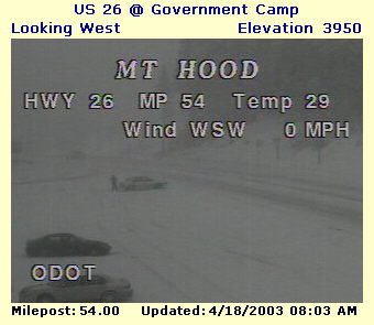
Bruce B. Johnson
OregonPhotos.com
April 17, 2003
"66 out of 70," May 8 Rain update: Rainy? ..Since the gloom and rain descended in late February,
66 out of the last 70 days have had measureable rain (94%). And
I call that DANG RAINY.
Sunshine? "Zero
and Zero some More"
April 30: So far the 65-day
period of February 26 through April 30 has featured a very
Oregon Duck-ish ZERO clear days* (definition below). That's correct,
not a single clear day in over two months! March 2003 had ZERO
clear days, and April 2003 also lanquished with ZERO clear days....
please recall that this period is "Spring Time" in the
Willamette Valley, when long-term climate stats claim that our
typical winter gloom is supposed to be easing up considerably!
Definition: "CLEAR"---
The Weather Service official definition of "clear" does
not require a cloudless day with sunshine all day, it merely
rates days on a 0-10 scale, and anything from 0-3 cloudiness will
be recorded as a "clear" day.
"1 out of 97"---Early June Sunshine update: Hallejuah!
May 2nd. squeaked into the category of "clear" with
a cloudiness rating of 3.... But since the 2nd, there have been
no further clear days, so as I write this on June 1, we have had
a GRAND TOTAL of a single clear day for the period of February
26th through June 1 (this is 1 out of 97 days, which is a lowly
1 percent of days being clear!). Today's 5-day weather forecast
gives much hope that the Willamette Valley's blessed summer weather
pattern is finally establishing itself (see * below).
March, April, May 2003 Grand
Finale count of Clear days: March= zero. April= zero. May=
one. THAT'S GLOOMY!
June 4: Sunny Spell? ..If you
define a "sunny spell" as three days in a row which
rate as "clear," then February 6-8 was Portland's last
sunny spell--- and as of today, June 4th, we are finally having
another Sunny Spell-- which made it it nearly four months
between sunny spells in Portland.... I call that GLOOMY SPRING
2003.
Extreme
Oregon, June 6th. Is this Global Warming?
It's a broiling hot 100 degrees
today! It's June 6th, and 100 official degrees today where I live
near Aurora, and not a cloud in the sky all day.... But then on
June 9th we shiver with a high of only 65.
"Oregon, A State of Extremes,"
yes, our State Climatologist really hit it on the head.... Oregon,
Green, mild, misty, gloomy, you Liar. You deceiver! The facts,
based on official Portland Airport readings: June 4, high of 91.
June 5, high of 96. June 6, high of 98. June 7, high of 91....
Records standing for 20-40 years have fallen hard during the past
four days. And then we shiver only 3 days later....Is this Global
Warming?
As a whole, June 2003 continued
the Gloomy Spring 2003 trend. There were only 11 clear days, and
this despite two raging hot spells during a month that was exceptionally
dry--- but not mostly clear and sunny! The extreme temperature
fluctuations continued during the month, eg. June 17th with a
summery 89 degrees, and June 18th with a high of only 69 on a
chilly, bleak day....At June's end, it seemed as though Gloomy
Spring 2003 had not yet released its grip..... Check out "Gloomy
Spring 2005" to see a similar pattern of a late winter
sunny spell, followed by a very depressing Spring/early summer.
July 2003 brought what seemed like genuine Summer--some hot
weather and almost twice as many clear days as June--- yet Gloomy
Spring 2003 was not far away, and a 97 degree reading on July
30th, was followed less than a week later with a chilling daily
high of only 68 degrees, which broke long-term records for the
date (August 5th)..... If one believes in Global Warming, events
like August 5th might lead to a conclusion that, whatever mechanisms
fuel global warming, they are not strong enough to offset more
routine weather and climate patterns that cause such a cold day
to intrude so rudely right into the heart of our Summer-- into
what climate records tell us ought to be the three hottest, clearest
weeks of summer for the Willamette Valley.
August 2003....Hey, Rain Gods, what's happened to
the Sun?. It's August 22nd, and so far August has
been more or less cloudy, with August 5th having a downright chilly
high of only 68, and August 22nd reaching only 69 in both downtown
Portland and Salem....The somewhat un-summery official count so
far this month-- only 7 clear days, with only a single cloudless
day, only one day with a maximum of 90 degrees or more, and six
days with measureable rain. Maybe "Gloomy Spring 2003"
is never going to leave this year.
September 2003.... It's approaching midnight on September
6th, and I hear rain beginning to fall outdoors, with a temperature
of 59 degrees. The five-day forecast is for clouds, rain and showers,
with daytime temperatures rising to only 65-70 highs. Now it is September 9th, and it rained nearly
half an inch today with a high of 63. Are we about to have a "Gloomy
Fall 2003?"
Now it is September 9th, and it rained nearly
half an inch today with a high of 63. Are we about to have a "Gloomy
Fall 2003?"
Heat Wave 2003? I've
heard several townfolk this summer complaining about what a scorching
hot summer it has been...However, if one defines a "heat
wave" as three or more consecutive days with highs of 90
or more, Summer 2003's longest heat wave was a mere four days
long! The hottest day was 100 degrees on July 29th.
On September 13th the Weather
Gods smiled briefly, and for one day we glimpsed Summer again,
with a high of 82 on a cloudless day. By September 16th, Timberline
Lodge on Mt. Hood had snow falling. A few days later we began
a very wonderful Indian Summer period-- Sept. 20-28, which featured Summer 2003's longest clear
spell, with nine consecutive days rated as "clear,"
and a record-breaking 95 degree high on September 27th!
October 2003 continued what this writer posits as
a climatic change pattern. Briefly, summers in Northwestern Oregon
appear to arrive later, and are generally cooler and more cloudy,
although not necessarily wetter, than long-term averages.... The
Fall-time, on the other hand, appears to have become our most
sunny period of the year, and this September/October 2003 certainly
substantiated this theory, most especially with a hot spell which
began on October 16th and did not end until October 28th-- there
were 10 days with highs of 70 or more, including a record-breaking 81 degrees on October
21.
Then in late October
2003, a mini-drought began, with only 0.34 inches of rain falling
from October 21 to November 9th (20 days). Rainfall normals for
this time period would be 2.50 inches, over seven times as much!
But despite the drought, the heat and sunniness was over, with
these 20 days ushering in some really cold days and only two days
rated as clear. In fact, on November 1st, 26 degrees was recorded
at the Portland Airport, tying the coldest it had been in all
of both 2002 and 2003.
Some now believe we may
finally experience a truly old-fashioned, frigid winter in the
Willamette Valley. Let's wait and see on that...May, 2004 Update:
the extreme cold winter did not occur, although there was a notable
snow/ice storm in early January..... But then April, 2004 ushered
in a major heat wave where April had every sembalance of July!
April 2004--
Heat Wave Strikes!
April 1st began auspiciously with
a clear day, then April 3rd hit 80 in some parts of the Willamette
Valley, 77 officially at PDX.... April 11 topped 80, with an 81....April
26 came close to 90, with a sweltering 86... Many records were
broken during the month-long period of April 3-May 3, 2004, where
there were 11 days with highs over 75, and 6 days where the highs
were 80 or above...And there were 8 days rating as clear,
including three rating a beautiful cloudless "0" (remember
that in 2003, March/April/May combined had only a single
clear day!)......Officially, April 2004 had the warmest average
high temperature ever recorded by the Weather Service in
Portland, and also scored the warmest mean temperature for April
ever recorded!........2004 was such an unbelievable reversal
from Spring 2003's gloom, again reminding us that Oregon is
truly "A State of Extremes."
..... Of course, being a State
of extremes meant that a big reversal from April's early summer
would soon occur. True to form, the gloom rolled in around the
first of May, and for the next 38 days , Portland was predominantly
cool, rainy and cloudy, with not a single clear day being recorded
right up into the middle of June! Of course, Portland's famous
Rose Festival had its usual rain and shivery temperatures
for the pleasure of the Rose Queen and her Princesses!
Link to "Oregon
Hot and Cold Records" page
More detail on Global Warming in Oregon (see bottom
of the page)
Note: the above statistics are based
on the official measurements at the main Weather Service office
at the Portland International Airport (PDX).
* The dreamed-for summer weather pattern
that brings sunny spells and hot temperatures consists typically
of a thermal low nudging up the Oregon Coast to at least the Central
Coast, flanked by a strong High pressure area east of the Cascade
Mountains. This combination will set up dry, hot easterly winds
and often will last for several days to a week or more.
On a related note: A "Mediterranean
Climate" has been alleged for Western Oregon in some texts
I have read, but the assertion seems inaccurate when applied to
the Upper Willamette Valley, where summertimes are marked by frequent
marine air incursions, "early morning clouds," and even
cool rain fronts slipping down from Canada, all of which blight
the hopes of any extended periods of hot, dry, sunny weather.
Only the Rogue River Valley in Southwestern Oregon comes close
to meeting a Mediterranean climate definition, in this writer's
opinion, and travelers seeking hot, dry, sunny summers will not
be disappointed with the Rogue River Valley!
 E-mailer: click
to communicate about weather topics (brucej@Oregonphotos.com)
E-mailer: click
to communicate about weather topics (brucej@Oregonphotos.com)

Back
to Main Oregon Weather Page
Page last revised June
6, 2006, reviewed 6/16/2020