The Pacific
Northwest/Portland/Vancouver Area Spring/Summer 2011 Notes: "This
is Global Warming?"
In fact, this preliminary
discussion includes both Western Oregon and Western Washington
July 22-August 4 Discussion,
followed by summary through September 30, 2011:
Supposedly, it was a very prolonged La
Nina event that cursed our entire region Spring and Summer 2011.
All the way from the Canadian border to the California border,
the cloudiness was depressing, and several of the months were
extremely wet, too. Mostly, it was presistently cool/chilly, for
example, as of August 15th, Portland still had not even had a
90-degree day! (for regional details, click
here). From Seattle to Portland, our tomatoes struggled to
reach maturity even at the end of August.... 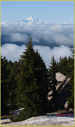 The
highest mountain trails remained under snow into mid-August with
near-record, ultra-late snow and retarded snow melting rates.
Finally, just as most depressed residents were about to give up
all hope of Summer, nine glorious days of clear skies and summer-like
temperatures blessed the region during the first half of September!
(click to skip to this section)
The
highest mountain trails remained under snow into mid-August with
near-record, ultra-late snow and retarded snow melting rates.
Finally, just as most depressed residents were about to give up
all hope of Summer, nine glorious days of clear skies and summer-like
temperatures blessed the region during the first half of September!
(click to skip to this section)
Late July--- In the July 22 image to the left, taken on Oregon's
Mt. Hood at Timberline Lodge, the aspect looks like late June,
with snow still on the ground at the Lodge, and distant Mt. Jefferson
looking quite winter-like. Additional research showed that as
of July 22 up in the Washington Cascades, there were still 64
inches of snow at the Mt. Baker Ski Area (only 4,200 ft. elevation),
and checking the trail reports from Olympic National Park revealed
reports of deep snow on many trails even lower than 4,200 ft,
and comments that most of the high country lakes were still partly
to mostly frozen!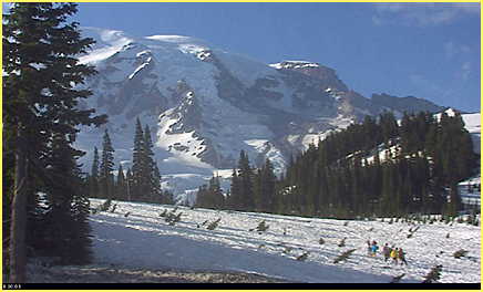 The second picture
is from 5,500 feet on Mt. Rainier's south side. It is also July
22nd in this picture, and the view on August 4th looked basically
the same...(click
here to
see the August 4th. view, still very snow-covered). Then, view
an even more shocking scene from August 12th in the picture of
the hiker).
The second picture
is from 5,500 feet on Mt. Rainier's south side. It is also July
22nd in this picture, and the view on August 4th looked basically
the same...(click
here to
see the August 4th. view, still very snow-covered). Then, view
an even more shocking scene from August 12th in the picture of
the hiker).
On Mt. Rainier's
south side, in the Paradise Lodge area (see picture above), the
world-famous wildflower meadows are vanished this summer. They
are still buried under deep snow. If you want to see the flowers
this year, you'd better aim for late August! In the picture's
lower right corner, note the small group of hikers; they're not
smelling the flowers and one would hope they are wearing stout,
waterproof boots! On July 29th, the Mt. Rainier Park website had
this conditions report: "Although many trails park-wide are
still under snow, all park roads are open, as are most of the
lower-elevation trails. The current snowline is around 5000 feet.
Due to heavy snowfall this past winter (2010-2011), melt-out is
not expected until sometime in August." Please see my picture from
August 12th
near Paradise!
August
19, 2011--- Over most of Western Washington
and Western Oregon it remained unseasonably cool and cloudy. Very
un-summery days were common, such as July 14th in Olympia, where
the high was 61 degrees with rain! Even though it was now into
the latter half of Summer, many days struggled to reach daily
maximums four to eight degrees below normal, while daily minimums
were often more or less normal, all the result of abnormally cool,
humid air and presistent cloud cover (click to
see satellite photos) that prevented the normal summer pattern
that clear skies would cause (large diurnal swings between day
and night). This pattern was especially true in the highly populated
Puget Sound region, where Sea-Tac Airport (Seattle) recorded only
four days which I would rate as "cloudless" between
March 1 and August 19 (Weather Service sky ratings of 0 to 1).......
Read my notes from Summer 2005 for
my analysis and predictions.
Temperatures--- As of
August 19th, 2011, here is a regional
summary of just how incredibly cool it was: Sea-Tac (Seattle)
as of August 19th had experienced only a few days above 80; the
three highest of which were 84, 83 and 81, and as of August 19th
it had been 80 or above in August only one time, and that a mere
81 degrees....... Further south, Portland had not yet hit 90;
their three hottest days as of August 19th had been 87, 87, and
86..... Even further south in Eugene, the summer had only hit
90 once; the three hottest days at 90, 88, and 86..... Finally,
down near the California border, normally scorching-hot Medford
had not even hit 100; its three hottest days at 97, 96, and 95. Many cities
in the region were poised to set "cool summer" records.
--- (Sept. 30th update: Medford failed to reach 100 for summer 2011, a
real rarity for Medford; however, early September did surprisingly
bring Medford's most prolonged and hottest summer weather, with
99 degrees hit four times between Sept. 4 and Sept. 10... Meanwhile,
up in the Puget Sound, neither Seattle nor Olympia ever got beyond
the high 80s this entire summer; Seattle reached only 87, while
in Olympia 2011's highest temperature was only 88, and that reached
on September 11th, a very late date that was truly indicative
of the disturbance in the normal climatic patterns that had beset
Summer 2011.)
Clear Days: Summer to most of us means blue skies and sunshine.
Puget Sound suffered severely in this category during Summer 2011.
Even by the National Weather Service's liberal definition of a
"clear" day, which allows cloudiness up to "3"
on their 10 point scale, Sea-Tac allowed only 28 "clear"
days between June 1 and Sept. 30th, and only four of those "clear"
days ranked as "cloudless." For comparison, Medford
basked under 100 clear days, of which an astonishing 62 were rated
as cloudless!
On the plus side all
authorities agreed  that 2011 had ample summer water supplies!
August
4, 2011, snow still covered the famous wildflower meadows near
Paradise Lodge, beginning to set some real records here! The snows
persisted despite several days of summery weather that had finally
arrived in the Washington Cascades.
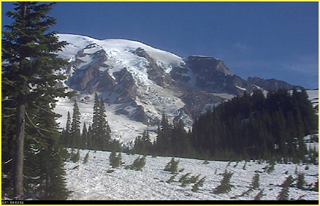
And, finally, below is a shocking picture
from a hike on Mt. Rainier that my son and I did on AUGUST 12,
2011. We were at only 5400 feet, just a few minutes hiking away
from the lower parking lot at Paradise. The aspect here most closely
resembles a normal year in mid-June, NOT MID-AUGUST... The snow
in these vast wooded tracts was generally two to five feet in
depth. Unless the remainder of August suffers a major heat wave,
I do not think these snows will be entirely gone even by the beginning
of September...... September of course is often when Rainier is
hit by an early season snowstorm or two!
August 12, 2011 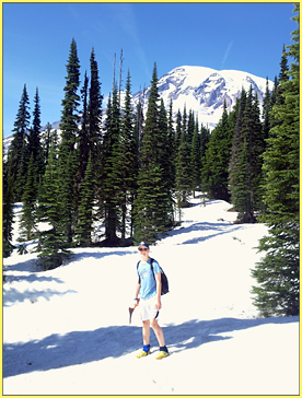 5400 feet
Portland
Area Weather Recap, Summer 2005
(October
20, 2005 Recap)
"Summer 2005 Fizzles
Out After a Mediocre Showing"
Subtitle: "This is
Global Warming?"
Summer 2005 in the Portland area
ended on a cool note, with only two minor heat waves the entire
summer. The highest temperature was only 96, recorded one time.
It is a rare summer when Portland doesn't hit 100 degrees at least
once or twice, and rare that there are not two to four heat waves
that last several days apiece. (my definition of "heat wave"
is three or more days in a row with highs of 90 or above).
Summer 2005
started late, ended early, and never really got very hot.
Sept. 8-- the day hit 84 for a
high. This was the last really warm summertime-type day in the
Portland area (my definition is any day showing a high of 80 or
more).... How many months will it be before Portland hits 80 degrees
again? (based on history, it is likely to be 7-8 months, which
means not until April or May; eg. the all-time record highs for
April have not been 80 or above until the 12th of the month (82
degrees, April 12, 1943).
Sept. 28-- 76 degrees---the last
day in Portland that showed a high of 75 or more.
Sept. 26th-- the last day in the
Portland area rated as "clear" by the Weather Service
on their scale of 0-10 cloudiness, where 0-3 rates as a clear
day.
Sept. 23-26-- the last "clear
spell" in Portland (defined as three or more clear days in
a row). How many months will it be before Portland sees another
clear spell? (based on history, it is likely to be between 2 and
5 months).
 October
1-20. So far there have been no clear days, one partly cloudy
day, and the daily highs have remained cool, never even hitting
70.
October
1-20. So far there have been no clear days, one partly cloudy
day, and the daily highs have remained cool, never even hitting
70.
Comparisons with past heat records--- October 2, 1970, Portland
has a high of 90. Salem has an even hotter high of 93... And in
1980 this date, Medford was up to 99 degrees.
October 3, 1979, Portland was 86, and Medford hit 96…. In
1932 this date, Salem hit a very summery 92 degrees!
Noting the paragraphs above, I
ask the reader: If there is so much global warming, why are many
of the record highs for the Portland area found so far back in
history, before the era usually associated with global warming?
WINTERTIMES: I also ask why the
proven fact of overall global warming has seemingly focused its
effects on Oregon's wintertimes. Most experts agree that there's
been a long-term, gradual lessening of lowland winter snows and
diminishment of the wintertime arctic air outbreaks that formerly
brought massive cold to Oregon, and Oregon's glaciers have radically
shrunk from what they were when Oregon was being settled in the
late 1800s..... Meanwhile,
summertimes in Oregon seem to have been altered; however, not
in the direction of increased warmth and sunshine. Examining the data, it's clear that long
term heat records are not being shattered all the time, and overall
there hasn't been an increase in the yearly amounts of truly hot
and clear weather. ... Instead, we seem to be seeing a
marked delay in the onset of Oregon's summer--- June and the first
half of July are often persistently cloudy and without any true
heat, certainly a change very disappointing to most of the Northwest's
sun-starved residents, and especially frustrating to school children
on their summer vacations!.... The arrival of the settled hot/dry/sunny
weather now seems to arrive "sometime" during the latter
half of July--- but then summer-like conditions seem to persist
one to three weeks later into the Fall than in past decades, once
again frustrating school children who see all the warm weather
from inside their classrooms!. (Note: this is my theory, developed
over the past several years, and may not prove to be a long-term
pattern).
ADDENDUM. Here's another paradoxical item related to the
manisfestations of global warming in the Pacific Northwest------
Unnoticed by most Oregonians, the Willamette Valley suffered all-time
record lows in early Fall 2002--- once on Oct. 31 (Halloween),
and again on November 1. This was a record-breaking early-season
cold wave all over the Willamette Valley; example, Eugene recorded
a low of 17 degrees on Halloween, and 16 degrees the following
night! Events like 2002's Fall cold wave, and 2005 and 2011's
cool, short summers seemingly dispute the concept of global warming.
In fact, such cold makes it easier to suspect an oncoming Ice
Age than to trust in global warming!
The
Future of Oregon's Snow Sports if Global Warming is True
Back
to Portland Main Page
Back
to Main Oregon Climate Pages
OregonPhotos.com
 OregonPhotos.com
Page last reviewed
October 10, 2022
OregonPhotos.com
Page last reviewed
October 10, 2022