 THE MOUNTAINS SURROUNDING OSPTHE MOUNTAINS SURROUNDING OSP
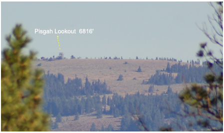
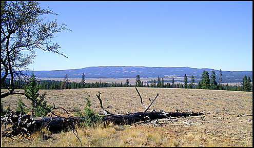
We are standing high at the north edge of OSP. We are at 5,000 feet, looking across the eight mile long sweep of Big Summit Prarie at 4500 feet. The long mass of Mt. Pisgah lies at a distance of about 12 miles. Pisgah is one of what I call the "nearly 7000 footers," a grouping of peaks that cluster around our OSP site to the west, north and east (the four are Lookout, Round Mtn, Pisgah, and Spanish Peak)..Pisgah's ultimate summit, with the lookout atop it, lies at about 6,830 feet.
Pisgah's summit area, like Lookout Mountain's, has extensive terrain that is capable of providing some of the best cross-country skiing in Oregon. However, unlike Lookout Mountain's high areas, the high areas of Pisgah are locked away in the winter--- there are just too many miles of snowed-over access roads to make them a practical destination for anyone but determined expeditioners or folks on snowmobiles.
The summit ridge that is so evident from OSP runs at an altitude of over 6,500 feet for 3 1/2 miles, traversing the space between the lookout station and East Point at 6625'.
Bridge Creek:... 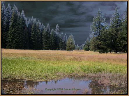 Meanwhile,
there is a whole other ridge system that is part of Mt. Pisgah,
but invisible behind the dominant ridge we see from OSP; this
invisible ridge forms the north side of the basin containing the
headwaters of Bridge Creek. Its highest point is the very scenic
and aptly-named "North Point," at 6607 ft and with serious
cliffs falling off to the north.. Image: headwaters of
Bridge Creek-- this 6100 ft.meadow is along the road leading up
to the lookout from the Walton Lake side. These meadows on the
north side of Pisgah's summit show us a much greener/lusher aspect
than the sun-baked southern side we see from OSP....
Meanwhile,
there is a whole other ridge system that is part of Mt. Pisgah,
but invisible behind the dominant ridge we see from OSP; this
invisible ridge forms the north side of the basin containing the
headwaters of Bridge Creek. Its highest point is the very scenic
and aptly-named "North Point," at 6607 ft and with serious
cliffs falling off to the north.. Image: headwaters of
Bridge Creek-- this 6100 ft.meadow is along the road leading up
to the lookout from the Walton Lake side. These meadows on the
north side of Pisgah's summit show us a much greener/lusher aspect
than the sun-baked southern side we see from OSP....
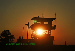
If one were circumnavigate the ridgelines around the headwaters of Bridge Creek, the trip is a bit over 9 miles of cross-country hiking. The terrain is somewhat more forested than Lookout Mtn.'s summit area, but still interesting and varied between forests and open areas. ... If windy on the ridges, you can always find shelter by skiing down into the canyons. Bridge Creek in particular, on the north, offers something close to 400 feet of descent before the forest closes in too much to be pleasant and the canyon steepens too much. Bridge Creek and its associated perennial springs provide the domestic water supply for the town of Mitchell, elev. 2760, far below alongside Hwy 26. The highest reaches of Bridge Creek also shelter one of Oregon's smallest and newest Wilderness Areas, that being the Bridge Creek Wilderness, 5400 acres, established in 1984. Below are two pictures of the beautiful Pisgah lookout tower, one from right beside it with much smoke from 2003's B&B Complex Fire mucking things up, and the second a picture taken from 12 miles away, down at OSP.
PISGAH ASTRONOMY: Latest
News: During OSP 2010, I was told that a small group was up on
the top of Mt. Pisgah sampling PISGAH ASTRONOMY! I have explored the summit areas of Pisgah
on three occasions over the years, beginning with an exploratory
junket in June of 1992-- that was during the period when the OSP
had decided to abandon the Steens Mountain but had not yet settled
on Indian Trail Springs. I have slept up on top near the lookout
tower and its friendly long-term staff (Mike Graham*). That was
on two occasions, but never with more than binoculars to do astronomy
with (see this star trails picture
from the top)..... NEVERTHELESS, it was easy for me to see the
benefits which the added 1700+ feet of elevation caused! My choice
of a Mt. Pisgah high-altitude Star party site was found
0.5 miles east of the lookout tower. It's a "meadow"
that looks like it was scraped off years ago by a road grader.
It's about 270 feet x 130 feet, 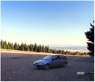 and
has about 30 feet of gradient. The good news is that there are
quite a few nice shady campsites in the forest on the meadow fringes,
and, best yet, the elevation is a healthy 6,680 feet (this picture
was taken in 1992).... The meadow is oriented generally north-south,
so it has an essentially perfect southern horizon. From the meadow,
I could plainly see our OSP site far below (just over the top
of the blue car)... Through my 12x60 binoculars it was easy to
see the specks of many RVs and cars. The meadow's sky had that
high altitude cast to it, very deep blue running far down toward
the horizon, and, yes, even in the very clear air of Eastern Oregon,
there was a layer of smoke/haze visible lower down, yes, affecting
OSP, but at 6680 feet we appeared to be ABOVE IT, into the very
best of airs for serious astronomy! *(Mike also suggested other
possible good astro sites: those were Snow Mountain (7163 ft,
41 air miles SE of OSP site; Lutsey Point; and Spanish
Peak).
and
has about 30 feet of gradient. The good news is that there are
quite a few nice shady campsites in the forest on the meadow fringes,
and, best yet, the elevation is a healthy 6,680 feet (this picture
was taken in 1992).... The meadow is oriented generally north-south,
so it has an essentially perfect southern horizon. From the meadow,
I could plainly see our OSP site far below (just over the top
of the blue car)... Through my 12x60 binoculars it was easy to
see the specks of many RVs and cars. The meadow's sky had that
high altitude cast to it, very deep blue running far down toward
the horizon, and, yes, even in the very clear air of Eastern Oregon,
there was a layer of smoke/haze visible lower down, yes, affecting
OSP, but at 6680 feet we appeared to be ABOVE IT, into the very
best of airs for serious astronomy! *(Mike also suggested other
possible good astro sites: those were Snow Mountain (7163 ft,
41 air miles SE of OSP site; Lutsey Point; and Spanish
Peak).
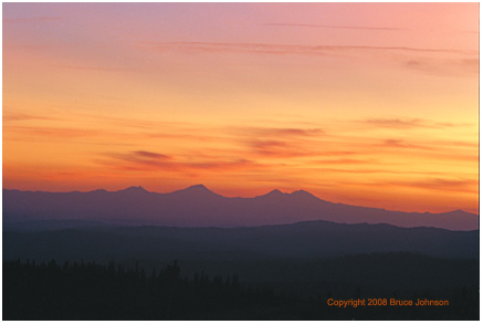
Up at the summit of Pisgah, just south of the lookout tower, there are some very picturesque groves of mountain mahogany trees (Carcocarpus, a member of the Rose family, a nitrogen-fixing plant that is a true desert tree, and is common in all the desert ranges of Nevada)... Mahogany only grows where sunshine is plentiful, and thus is absent from moister, more shady slopes. From this summit grove there's a stirring view of the Cascade Range to the west, dominated by the peaks of the Three Sisters, a full 80 air miles away. For a picture of a mountain mahogany tree, go back to the image at the top of this page, and you'll see one about 15 feet tall on the left edge of the image....For people on site at OSP, a good example of a Mountain Mahogany tree can be found growing at the base of Lightning Tree (click). Below is the sunset view toward the Three Sisters from Pisgah's summit.
The summit plateaus of Pisgah would potentially provide a several high-altitude observing sites for groups of up to 30-50 people, and there is even Pisgah Spring at 6223', a source of water, just NE of the summit--- HOWEVER, the roads leading to the summit area are all fairly to very primitive, bouncy and dusty, so appropriate care for both vehicles and optics must be considered.
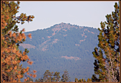 Round
Mountain also had fire lookouts on its summit, beginning
in the 1930s and extending all the way to 1972. Through binoculars,
one can see a big array of solar-powered communications equipment
on the summit, and there is a road accessing it all. However,
the summit ara is very small and limited, with certainly no room
for anything but a couple cars, meaning little room to set up
a serious observing session, and the road leading to the top is
similarly lacking in any large open spaces that are flat enough
and with good enough horizons. This image was taken from the OSP
site in 2007, with morning sunlight.
Round
Mountain also had fire lookouts on its summit, beginning
in the 1930s and extending all the way to 1972. Through binoculars,
one can see a big array of solar-powered communications equipment
on the summit, and there is a road accessing it all. However,
the summit ara is very small and limited, with certainly no room
for anything but a couple cars, meaning little room to set up
a serious observing session, and the road leading to the top is
similarly lacking in any large open spaces that are flat enough
and with good enough horizons. This image was taken from the OSP
site in 2007, with morning sunlight.
Wild Horses: Interestingly, in the late 1970s I observed three wild horses while on a hike up to the top of Round Mountain. Years later, I discovered on a topographic map of the area that there is a "Wildhorse Spring" at 6060 feet, on the mountain's south side just east of the trail. The spring is thus in the general vicinity of where I saw the wild horses! What kind of amazing coincidence was it that I was blessed to see those horses that day at a placed named for them!
And speaking of wildlife in this part of the Ochocos, please don't miss the chance to see Pronghorn Antelopes! You will find them mixed in with the many cattle out on Big Summit Prarie! You'll probably need a good pair of binoculars to clearly separate them out from all those cattle, especially the cattle that are of the brown-rust-white color schemes similar to Pronghorn colors.
PICTURE FOR SALE: In addition to selling custom prints of all the OSP Group Photos from past years, I am also going to offer selected other OSP-related scenes., such as the Lookout Mountain panorama. Contact me.
"Campers of All Persuasions, a Photo Essay about the Variety of Ways We Make Our Homes At The Oregon Star Party." Click for
the first images from that photo essay.
Also soon to come: more on other locations such as the OSP swimming hole at Upper Falls.