Central
Oregon Mountains
with links to the
Pacific Crest Trail, Oregon classic fire lookouts, the Oregon Skyline Trail, and historic wilderness shelters
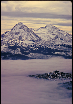
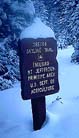
"Sisters
Cloudland." Seas of soft cloud drift over the black, jagged
lavas of McKenzie Pass in this scene from a winter climb of Mt.
Washington. The Pacific Crest Trail runs through the middle of
the picture beneath the clouds. North and Middle Sisters rise
somberly to 10,000 ft. in the distance. Behind us, a few miles
NW and 3,000 ft. lower, is Hoodoo Ski area, and then Highway 22
and Santiam Pass with its bustle of traffic. Click here
to communicate via email (jupiterman47@gmail.com) if interested in purchasing
a print of "Sisters Cloudland."
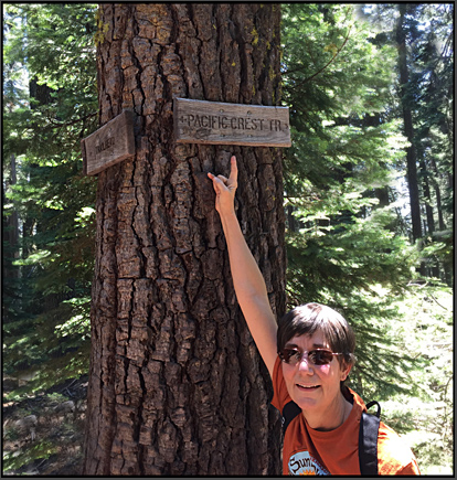
Oregon's two long distance trails along the Cascade
Crest: the PCT, and its predecessor,
The Oregon Skyline Trail
Many years before
the modern Pacific Crest Trail came into existence, Oregon developed
a visionary trail along the crest of the Cascade Mountains. It
ran north to south all the way from Mt. Hood to Crater Lake. It
was named The Oregon
Skyline Trail.
Below are several pages concerned with the Skyline Trail and some
other related historic trails near it... Notes: Click here to find remarks on vanished Wilderness Shelters....
Click here to skip to my Pacific Crest Trail
pages.
Oregon's
section of the Pacific Crest Trail System
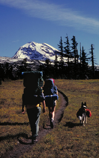
Above, left:
on the PCT near South Sister in October
FOUR PCT BOOK
RECOMMENDATIONS:
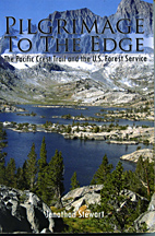
My first recommendation
is "Pilgrimage
to the Edge."
It's for PCT lovers, and for those interested in the history and
evolution of the intricate and often conflictful interface between
the official public land managers and the environmentalist movement.
This 2010 book is also just a fine trail read with chapters of
first-person accounts of all the trail sections from Canada to
Mexico. Softbound, 491 pages, published 2010, ISBN 978-1-4535-9998-3.
Author: Jonathan
Stewart, a
graduate of Medford High School in Southern Oregon, and a journalism
major in college, Jon is a unique individual whose personality
combines hardcore trail hiker with a long and varied background
as a Forest Service insider and journalist. He is also lifetime
friend of mine who was with me on my very first backpacking and
climbing trips. Publisher of "Pilgrimage" is Xlibris.
ISBN: 978-1-4535-9998-3. It's available on Amazon.
Note to readers:
if you have trouble finding any of Jon's books, please email me
at oldgear@Oregonphotos.com -- I have a direct line to Jon, who
usually has all his books in stock for a price of about $20 plus
shipping.
My second recommendation
is Jon's recently-completed third trail book, "The Plateau of Doubt." This time the locale
is the tortured desert terrain of the Colorado Plateau. 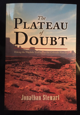 Jon is
one of only a couple dozen hardy souls to have completed the rough
and dangerous 850 mile Hayduke Trail. His new book about the adventure
is subtitled "Hiking the Hayduke Trail across the Colorado
Plateau." Its 329 pages describe a true adventure of spirit
and grit. ISBN 978-1-4834-8088-6, Lulu Publishing Services. Amazon
has "Plateau" as an $8.99 Kindle book.
Jon is
one of only a couple dozen hardy souls to have completed the rough
and dangerous 850 mile Hayduke Trail. His new book about the adventure
is subtitled "Hiking the Hayduke Trail across the Colorado
Plateau." Its 329 pages describe a true adventure of spirit
and grit. ISBN 978-1-4834-8088-6, Lulu Publishing Services. Amazon
has "Plateau" as an $8.99 Kindle book.
My third recommendation
is Jon's 2014 "Walking
Away from the Land, Change at the Crest of a Continent," 528 pages, It's based
upon four years of walking the high trails of the Western U.S.
from the Rockies to the Pacific. Available in hardback, paperback,
e-book. Paperback ISBN is 978-1-4931-8092-9. It's available from
Amazon as either a print book or a Kindle book, or contact me
at oldgear@Oregonphotos.com-- Jon describes the thick book this
way: "It focuses on the 3200 mile hike of the Continental
Divide Trail I took a few years ago. It also speaks to the rapid
climatic and cultural changes affecting our nation's forests and
grasslands I saw along the way. It also includes a few memorable
lifelong adventures I shared with many of you over the past half
century."
My fourth recommendation
has got to be Cheryl Strayed's powerful, psychologically deep
book about her PCT trials and triumph. "Wild, from Lost to Found on the
Pacific Crest Trail." Cheryl
Strayed, a
Borzoi book published by Alfred A. Knopf copyright 2012, 315 pages.
Ms. Strayed lives in Portland, Oregon. She also has a website
and on
there you can find a list of her upcoming appearances and writing
workshops. Strayed's book is widely available. My own ten books
can be seen described at this link below:
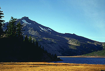
Ever-popular
Green Lake and South Sister Mountain. This lake is often snow-choked
until late July due to its elevation of close to 6500 feet. The
PCT passes to the west of this location, on the opposite flank
of South Sister, where Geologists have mounted a full-scale, highly-instrumented
Volcanic Alert--- the area in questions
is about 3 miles west of South Sister, and its surface has bulged
upward over 10 inches since late 1997. Over 50 million cubic yards
of magma has risen into the rocks far below the surface! And the
uplift continues.....This area was last active very recently,
at about the time of the birth of Jesus Christ, in the Rock Mesa
area, and also near Green Lake, seen in this image.
Lookout
Towers
Click this to
be awed by.. Mt. Pisgah Lookout ..whirling under the night sky! You'll also get acquainted
with some.. other Oregon lookouts ..--and
hopefully you'll decide that Oregon's remaining lookouts are a
heritage worth preserving.
Three
Sisters Wilderness History: Sunshine
Shelter, aka simply "Sunshine"
among climbers
elevation
6,400'
The long uphill
trudge through dense forests from Frog Camp formerly had a fine
reward at its end. Sunshine Shelter was a haven for soaked, tired
climbers and Skyline Trail backpackers for many, many years. I
have reports that in 1944, "Sunshine" was even hooked
up to the outside world via a US Forest Service phone line strung
among the trees from McKenzie Bridge Ranger Station.
But the sad fate
of Sunshine is that it was demolished and burned by the Forest
Service; my best report believes this occurred about 1973 (thanks,
Paul B.)
Its destruction*
was a piece of the movement that saw most of our National Forests
and Wildernesses loose their historic old lookout towers and shelters.
To me, Sunshine Shelter had a delightful ambiance, possessing
a sort of European Alps climbing hut feel.....On historic Oregon
Skyline Trail maps from the 1920's, a location marked "Camp
Riley" shows up at or near the site of Sunshine Shelter.
This was decades before the present Three Sisters Wilderness Area
had been created---back in the 20's and 30's, this was the "Three
Sisters Game Refuge," and horsemen and hunters ruled....The
area was designated as one of Oregon's first "Primitive"
Areas in 1937, and formally designated as a "Wild Area"
on 2/06/1957. At a size of 199,902 acres, it is second only to
the Eagle Cap Wilderness in size.
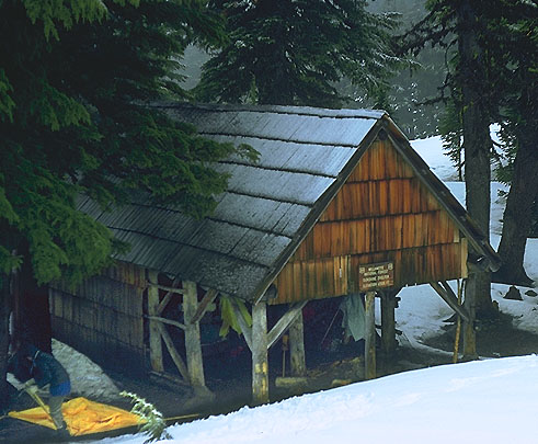
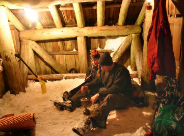
Below please
find a cozy image of a still-existing shelter, one of the few
shelters missed in the campaign of destruction. Unfortunately,
hikers themselves were sometimes the problem, such as at "Jack Shelter,"
which was
located just a couple miles hike north along the PCT from Santiam
Pass-- here hikers repeatedly burned campfires inside the shelter,
ultimately damaging it and leading to its destruction because
FS rules said such historic structures couldn't be altered with
modern materials for repairs- Jack Shelter was taken down in 1972--
it was one of my personal favorites. (click here to see image of Jack Shelter and a
1964 Map)....... Below, this image by Monte Dodge brings back
to my mind pleasant memories of the rustic security during bad
weather that these shelters offered to any and all at no cost.
This shelter is located in the Southern Cascades of Washington
State. Image credit: Monte Dodge.
 *
Please e-mail
me (jupiterman47@gmail.com) if you can supply an exact date, or
other details, regarding Sunshine Shelter's end, and I'll be happy
to include them on this webpage. I'm also interested in other
shelters you may know of---- By the way, I am Bruce Johnson, not
Bend-area photographer Bruce Jackson (many seem to confuse us).
*
Please e-mail
me (jupiterman47@gmail.com) if you can supply an exact date, or
other details, regarding Sunshine Shelter's end, and I'll be happy
to include them on this webpage. I'm also interested in other
shelters you may know of---- By the way, I am Bruce Johnson, not
Bend-area photographer Bruce Jackson (many seem to confuse us).
Back
to Central Oregon Main Page
Back to OregonPhotos Main Page of Subjects and Places
and our Search Engine, over 375 pages of content!
Page
last revised 01/04/2025
 several other pages, please click the picture