Old Oregon Lookout
Towers-- Mt. McLoughlin (page 1 of 3)
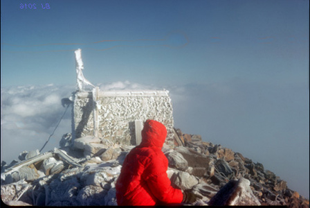
I cover Mt. McLoughlin
on three pages, this is the first page. The picture above is from
Nov. 1966. Note: on older maps McLoughlin was called "Mt.
Pitt." There were a total of two lookout buildings over the
years. They perched on the very highest point, at a lofty 9,495
feet elevation, some 2,000 feet above timberline! The picture
above shows the native stone foundation of the second lookout
on November 30, 1966. The winds were blowing from the northwest
at 50+ mph, flattening my big down parka against my back -- all
just a taste of the destructive power of wind, snow and ice that
ultimately reduced even the stone part of the lookout tower to
nothingness.
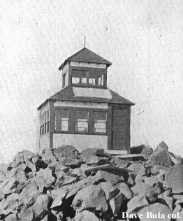
Let's
begin with the original lookout, erected in 1917, this old black
and white image is from 1920.
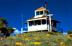
Now let's
jump ahead forty-four years to the 1964 color photo below. During
the intervening time, the wooden beauty above had been destroyed
by the fierce summit winds and replaced in about 1930 by a more
sturdy version with a native stone foundation. But after 35 years,
even that has been decimated.
 And by 1976, after another twelve years of
harsh mountain weather, more decay has ensued, and now the wooden
floor we stood on in 1964 has vanished, leaving only a stone shell,
usually chock-full of snow even in summer. Color image below taken
by me in 1976.
And by 1976, after another twelve years of
harsh mountain weather, more decay has ensued, and now the wooden
floor we stood on in 1964 has vanished, leaving only a stone shell,
usually chock-full of snow even in summer. Color image below taken
by me in 1976.
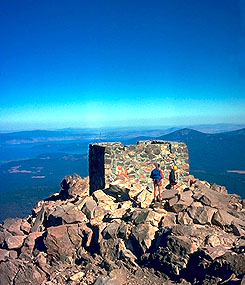 Year
2000. We see the near-total demise of this classy lookout. The
stones used to build the foundation were plucked from the summit
rocks, so the main thing that still lets us see the foundation
is the unnatural gray of the mortar used to cement the stones
together! (2017 images will be posted by October 5)
Year
2000. We see the near-total demise of this classy lookout. The
stones used to build the foundation were plucked from the summit
rocks, so the main thing that still lets us see the foundation
is the unnatural gray of the mortar used to cement the stones
together! (2017 images will be posted by October 5)
 ghlin
ghlin
Expanded content:
The High Cascades
weather at nearly 10,000 feet has not been kind to the Mt. Pitt
fire lookout buildings! In the early 1930s, the second version
of the lookout was a beautiful wood-structure with classy 360-degree
windows... It rooted itself to the
summit via the durable native rock foundation seen in the 1976
image. Previous to the 1930s lookout, a quaint two-story all-wood
lookout had clung to the wind-blasted summit since 1917 (see image
at page top from Dave Bula's collection). That wooden beauty was
replaced by the more bullet-proof version in the early 1930s due
to the ferocious summit winds...
The lookout building, like many of the other early lookouts placed
atop Oregon's highest peaks, proved to be a bad idea, frequently
unusable due to being either above the clouds or within the clouds,
thus making for poor viewing conditions for the persons within
trying to spot distant fires at much lower elevations!...History buffs will note that in those
early days, the peak was named Mt. Pitt. Nowadays, you'll find
it named Mt. McLoughlin on the maps, after Dr. John McLoughlin,
one of Oregon's most well-known pioneer statesmen. McLoughlin's
pointy peak is Oregon's most southerly major Cascades volcano.
In the image
from 2000 (see above), we are perched high in the sky at 9,500
ft... Medford, the Rogue River
Valley, Prospect and Butte Falls lie to our backs, as we look
eastward toward Harriman Lodge and Klamath Lake, which is a birder's
paradise. The shoulder of Pelican Butte rises about 8 miles away
in the 2000 image. Pelican Butte, at 8,000 ft., is the projected
home of a new ski resort that is locked in environmental controversy;
it is hoping to join Oregon's other major downhill skiing areas,
but the latest legal rulings look negative.
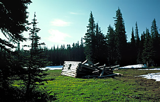
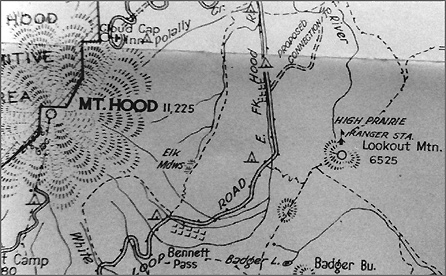
In the image below you see a ruined log cabin in
a meadow in the Mt. Hood National Forest. It dates from about
1911, when it was the home of the forest fire lookout on Lookout
Mountain (about 9 air miles east of Mt. Hood). During the daytimes,
the lookout climbed to the 6525 ft. summit of Lookout Mountain
to search for fires with his alidade instrument. During the nights,
he slept in this high meadow on the north side of the peak amidst
the flowers and sounds of running waters. By 1914, a new cabin
was constructed atop the peak, and gradually the old cabin fell
into ruin, although the time frame of that is uncertain as maps
from about 1930 show a "High Prarie Ranger Station"
at this location. My picture of the cabin below dates from 1976,
while the scan of the map is taken from the 1931 version of the
Oregon Skyline Trail map. Note that Mt. Hood aleady has its western
half protected in a "Mt. Hood Primitive Area." (link
to more from 1931
Map)

Page
Last Revised 02/03/2024