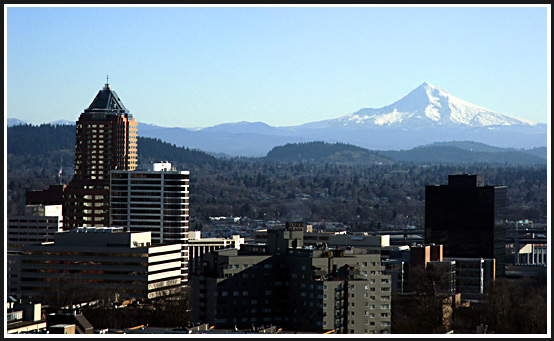
Like most major cities in the U.S., Portland often suffers from less than perfect visibility due to urban air pollution, not to mention the prevalence of rain, mists, fogs and the like in its damp Pacific Northwest climate. But the views get spectacular when the cold east winds blow down the Columbia River Gorge in the winter, bringing clear skies and low humidity! Rising to the east is Oregon's highest peak, Mt. Hood. One of the most perilous climbing routes on the mountain runs on the line between light and dark in the picture. It's Yocum Ridge, first climbed in 1959 by the Northwest's most legendary climber, Fred Beckey. Sadly, he passed away in Seattle in late 2017 at age 94.
Speaking of winter and cold east winds coming down the Gorge, let's travel back in time for a moment, to the very late part of the Pleistocene Age..... It's 15,000 years ago, less than a thousand years before the first humans reached Oregon.* (see footnotes)... It's been very cold for thousands of years, and now the Great Ice Age of the Pleistocene is beginning to loose its grip just a bit.... For several thousand years, the Portland area has been repeatedly decimated by cataclysmic floods that crash down the Columbia Gorge. These are the Missoula Floods, which were formerly called the Spokane Floods, and geologists estimate there were about 100 of them. Best estimates are that the last significant Ice Age floods were about 13,000 years ago.
In the image below, I will point out
a seemingly minor detail that begins to uncover the terrible force
of these floods...In the image, you will see a Butte; this is
300 foot high Kelly Butte, which rises just east of I-205; Division
St. passes along its north side, and Powell Blvd. passes along
its right (south) side. In the image, one can readily note that
Kelly Butte's left side is quite steep. This kind of steepening
is found all around the Portland area and is a direct result of
Missoula Flood erosive action tearing away whole sides of hills
and mountains.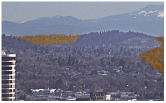 ..A
flood would pour into the Willamette Valley and the bigger ones
would rush all the way to Eugene, over a hundred miles south,
and then the waters would rebound and rush back out of the Valley
through the Columbia River channel, all in a period of about two
weeks.... In effect, the flood would erode in two weeks what Mother
Nature's normal erosion takes tens of thousands of years to accomplish
..A
flood would pour into the Willamette Valley and the bigger ones
would rush all the way to Eugene, over a hundred miles south,
and then the waters would rebound and rush back out of the Valley
through the Columbia River channel, all in a period of about two
weeks.... In effect, the flood would erode in two weeks what Mother
Nature's normal erosion takes tens of thousands of years to accomplish
In the image to the left, I have simulated an approaching medium size Missoula Flood. It's about five minutes away, churning across the flatlands of East Portland in a tsunami of unbelievable power, dirty, brown, like a liquid cement, full of sand, gravel, boulders, huge icebergs, tree trunks all moving at highway speeds of about 50 mph (roughly 5 times the speed of everyday flood waters, such as one might encounter when Johnson Creek floods). YOU ARE ABOUT TO BE WIPED OUT WHERE YOU STAND TAKING THIS PICTURE! THE SOLES OF YOUR FEET FEEL A DEEP RUMBLING. YOU NEED TO RUN VERY FAST UPHILL! ...."Medium Size" in the case of a Missoula Flood might mean the wave front is "only" 250 feet high, and therefore does not completely bury Kelly Butte; in my representation, I have Kelly Butte acting as a island in a river, with the flood separating around it. If one examines the SSE side of Kelly Butte (right above where the old drive-in movie theater was), one sees that that side of the butte is very much steepened, so much so that this side of the Butte was probably exposed to the strongest part of the passing floods.
* People? Experts formerly believed that there were no people around to be destroyed by these floods. However, the most recent finds of real archaeological evidence place Man in Oregon well before the ending of the Missoula floods period. Formerly, it was thought that Clovis Man was first to occupy America, but the newest finds from Paisley Caves in Eastern Oregon have been conclusively dated to 14,300 years ago, and the DNA evidence points to people of Siberian or East Asian descent (Dr. Dennis Jenkins from the University of Oregon has been in the forefront of this research). Nearby to Paisley Caves is famed Fort Rock Cave, where UO Anthropology Professor Dr. Luther Cressman discovered the renowned Fort Rock Sandals in the 1930s, later dated to 9,000 years ago. Just across the border in Washington, the famed find of the complete skeleton of "Kennewick Man" is accurately dated at 9,400 years old. Although the Bering Ice Bridge (Beringia) existed for thousands of years and was up to 1,000 miles broad, its greatest extent was during the most extreme part of the Ice Age when the great Canadian Ice Sheet had invaded Puget Sound and filled it all the way south past Olympia, and out to sea. Probably any would-be settlers could not negotiate the route south until a critical time period when the Ice Sheet had shrunk enough to free up a land route south, but before sea levels had had a chance to rise enough to erase the Land Bridge (the Bridge went back under water about 10,000 years ago).
Were there Animals around to be destroyed? Yes, uncounted multitudes were destroyed each time one of these floods would smash into Oregon. Let's move now to another page, where we will visit a refuge about one mile uphill from the place where the images on this page were taken: See: Refuge from the Floods!
The Washington scablands are where the Floods roared across before being funneled into the Columbia River Gorge and then into Portland: As the various flood events decimated huge parts of SE Washington, they left behind several waterfalls in the resistant basalt plateau. All the major ones are dry now except for Palouse Falls. It's well worth visiting and very scenic in any season; in fact, in 2014 it was named Washington's official State Waterfall. It's in a protected State park. The water in the falls empty into the Snake River, and thence into the Columbia.
The Big Picture: It is of great interest to realize that in the several billion year long history of our Planet, there have been several past Ice Ages, some even more severe and long-lasting than the series of Pleistocene glaciations which shaped our present landscape in the Pacific Northwest and generated the Ice Age Floods:
* Footnote: scientists are NOT in agreement about how and when early man took up residence in the Americas. Some lines of evidence point to multiple migrations during the Ice Age times, some even pushing times back to 30,000 years ago, with such estimates based on mitochondrial DNA studies. Some even posit that early settlers may have bypassed the Ice Age glaciers and the Bering land bridge entirely by simply sailing across the Pacific Ocean, like the Polynesians did.... Unearthed in 1932, the famed Clovis point from New Mexico could perhaps be called the starting point of the science, and was dated at 11,500 years ago.