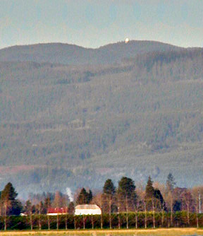
Laurel Mountain, Oregon's most rainy place, is just west of Dallas, Oregon. A rainfall record which this station set was in November of 2006, when very nearly 50 inches of rain fell in a single month! (yes, that was FIFTY inches of rain, over four feet of rain in one, thirty-day long month!).....A huge white domed installation dominates the 3,589 ft. summit---it's the same elevation as Bend, an Oregon city which thrives on only 12 inches of rain per year. The peak is also nearly the same elevation as Meacham, one of Oregon's very most frigid places
The white dome is a VOR radar station for aircraft navigation, and is manned by the FAA. On a clear day, the Pacific Ocean is visible, less than 25 miles distant.
Valsetz, a booming company-owned logging town, used to nestle on the south slopes of this mountain massif. In its day, Valsetz was probably the rainiest town in the entire State of Oregon. The town was razed when the company closed up shop and closed down the town a few decades ago. Getting to the Coast from Dallas via the site of Valsetz is a very interesting and lengthy journey; if you try it, it's best to have a more rugged vehicle like an SUV.
Page last reviewed October 2022