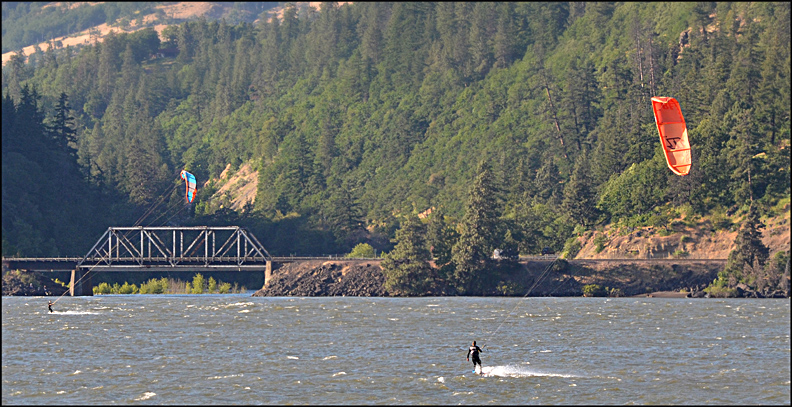
The central part of the Columbia River Gorge contains two smallish towns: Hood River on the Oregon side of the river, and White Salmon on the Washington side. During the summer season, their populations explode with thousands of recreationists, many headed for the wind-whipped waters of the Columbia River to do windsurfing and para-surfing (I think that's the name of what's pictured above).
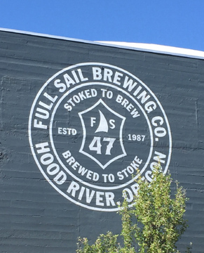
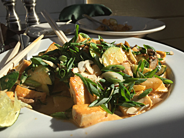
The huge main headquarters of Full Sail Brewing company is highly visible from the I-84 freeway as you pass through town. "Full Sail" of course refers to the windsurfing origins of the company in 1987. Get in there for beer tastings on a hot summer day! Nearby you'll find several good restaurants, like the Sixth St. Bistro and Pub with its wonderful shady outdoor seating and a menu of inspired dishes, like this one with an Asian flair. I ordered tofu but could have had chicken.
Hood River is dry compared to Portland. Look at the predominance of oak trees, that's one of the signals. At Hood River the rainfall is just a fraction of what the most rainy parts of the Gorge swim in a mere 20-30 miles to the west of town, where 60 to 80 inches of annual rainfall drench Eagle Creek, Cascade Locks and Multnomah Falls. ......................But also realize that Hood River's dryness is only relative: Drive east out of Hood River for about 30 miles and you'll pass Celilo Indian Village, where the landscape is treeless and rainfall is only 10 inches per year. (see picture near page bottom)
From Hood River, it's less than a 30 minute drive to the rain-soaked fir forests near Multnomah Falls (Link)...
In the Central Gorge around Hood River, it is common for summer days to reach over 90 degrees, and temps of 100 will happen every summer....Portland's "early morning clouds" rarely make it up the Gorge past Hood River, leaving the town and the areas further east with frequent cloudless days and heat to match....
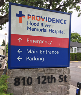
Although a small community, Hood River boasts a modern, well-equipped hospital that is part of the vast Providence Health System.
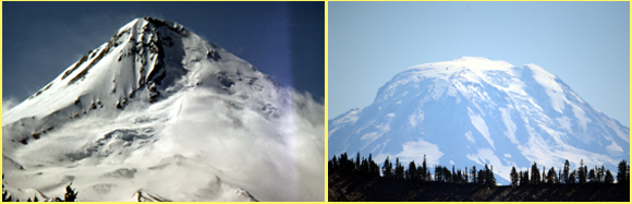
To a mountain lover like me, one of the joys of the Hood River area is the looming presence of the Northwest's second and third highest peaks: on the left, 11,245 ft Mt. Hood, Oregon's tallest peak and very visible from the upper Hood River Valley where the apple orchards blanket the land. And on the right, the immense bulk of Mt. Adams, 12,276 ft, the second tallest peak in the entire Cascade Range. Adams is especially impressive from the Trout Lake area.
For another amazing Oregon contrast,
you could drive to Mt. Hood from Hood River on Hwy 35, and within
an hour you would be standing at Timberline
Lodge, where the yearly snowfall of about 600 inches doesn't
melt away until June! (Skiers count on the fact that the only
reliable summertime skiing outside of Alaska thrives on
Mt. Hood, on the 8,000 foot Palmer Ice Field..... Many high-powered
downhill ski racing and training camps know this).
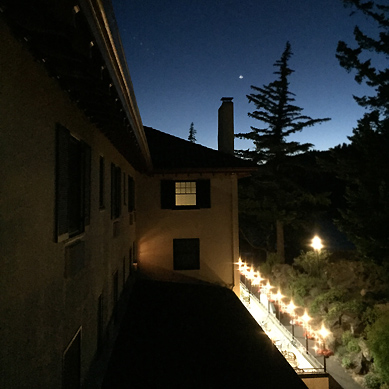
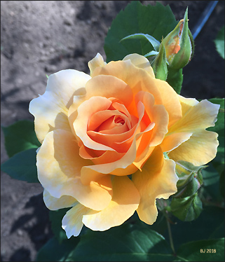
There are a number of posh places to stay in Hood River. The Columbia Gorge Hotel with its 1920s origins is especially notable. Here's a nightime picture out our third floor window with Venus shining in the twilight. The rose was found in the hotel's excellent rose garden.
The Goldendale Valley lies on the Washington side, some 35 miles from Hood River; it is the County seat of Klickitat County (Goldendale hosts a very fine public astronomical observatory, Goldendale Observatory State Park. An old friend of mine, Steve Stout, is in charge and can thrill you with the lore of astronomy).
In the Picture below, you've
now travelled some 30 miles east of Hood River, to where the dryness
has greatly intensified. We are about an hour's drive on I-84
from the rainforests of Eagle Creek in the central part of the
Gorge! In the Far Eastern Gorge, it's a land of wide open space
and big sky, and I love that about it. In the picture below, you're
standing on the Washington side, perhaps 8 miles west of the famous
MARYHILL MUSEUM and
STONEHENGE. 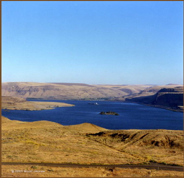 The
pictures looks down across the mighty Columbia River, which here
is actually named "Lake Celilo." On the far side, you
can glimpse the confluence of the Deschutes River with the Columbia
River....Upriver around 15 miles on the Washington side are the
extensive vineyards of Maryhill Winery. It's a sun-soaked plateau
above the Columbia River.
The
pictures looks down across the mighty Columbia River, which here
is actually named "Lake Celilo." On the far side, you
can glimpse the confluence of the Deschutes River with the Columbia
River....Upriver around 15 miles on the Washington side are the
extensive vineyards of Maryhill Winery. It's a sun-soaked plateau
above the Columbia River.
This river confluence in the picture is a sad place, two deaths happen here. One is current and ogoing, namely the beautiful Deschutes River ending its existence as it pours out its clean waters in the Columbia and vanishes.
Celilo Falls and Village, and link to two maps of the historic tribes of Oregon and of North America:
The second death is more profound: Back in 1957, this big blue lake buried one of the Northwest's most revered Native American cultural sites, the salmon-bounty of Celilo Falls. That was a grim Spring, the united tribes and bands of the entire region had lost a 12 year battle against the erection of The Dalles Dam .....Now all that remains is the tiny Indian village of Celio Village, looking decrepit and without heart. The Columbia River Indians, the River People, do not have a Reservation, it is only a small patch of Trust Land of under 10 acres. If you travel across what used to the the life-giving river you will find Indian petroglyphs, carved long ago into the basalt columns, when the rapacious Whites were not yet even a bad dream.... The petroglyphs are now in a Washington State Park named Horsethief Lake. "She Who Watches" is probably the most famous of the petroglyphs... Click here for link to two maps of the historic tribes of Oregon and of North America...Tommy Thompson, Hannah Sohappy, Howard Jim, Nancy Jim, Rock Creek Band, Wayam, The River People.
chutes State Park).