 Western Washington's
Driest Zone: the Sequim Rain ShadowWestern Washington's
Driest Zone: the Sequim Rain Shadow
Western Washington's
Driest Zone: the Sequim Rain ShadowWestern Washington's
Driest Zone: the Sequim Rain Shadow
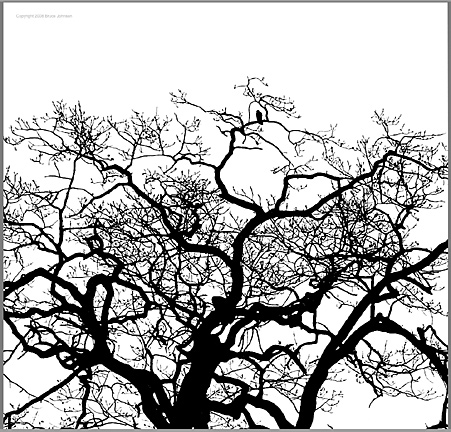
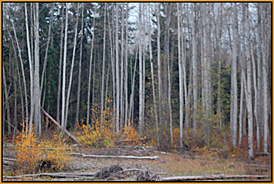
A dry zone tree, the Garry Oak, thrives on the praries around
Sequim. 
Sequim is a dry little town, in fact, the driest place in all of Western Washington, with a bare 16 inches of rainfall per year, only half of what the Seattle/Tacoma area receives, and less than a third of the massive amounts that drench the South Sound around Olympia. It's the huge mass of the Olympic Mountain range that ultimately causes these variations. With peaks up to nearly 8,000 feet high, the range lies directly in the path of the normal storm track, like a giant wall. Since the majority of rain-bearing storms, and especially the wettest ones, tend to attack the region from the SW, one notes a strong Rain Shadow effect on the NE side of the Olympics. In the first image on this page, I had spotted a bird perched in the topmost branches of a very large Garry Oak that grows near the town's Carrie Blake Park.
The rain shadow extends eastward, out
onto the nearby islands, eg. to Coupeville with just under 21
inches of rainfall, and to Anacortes in the San Juan Islands,
with just over 26 inches.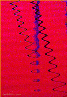 Image note: in the harbor* at Sequim I found the reflection of
several masts. I played with the intriquing image to achieve this
effect. (* John Wayne Marina near Sequim Bay Resort)
Image note: in the harbor* at Sequim I found the reflection of
several masts. I played with the intriquing image to achieve this
effect. (* John Wayne Marina near Sequim Bay Resort)
On the eastern shores of Puget Sound the rainfall increases, the driest site I could locate being Mt. Vernon at 32.3 inches. The main Seattle area has several recording sites, and they vary between about 35 and 37 inches per year (despite the fact that Seattle has a reputation as a wet West Coast city, the Sound's wettest large city is a lot wetter than Seattle- it's Olympia, with over 51 inches of annual rainfall)
David Britton maintains a website and a Facebook page with a great deal of current information about Washington's rainshadow areas, especially that portion including Sequim. I especially appreciated the results from a year-long study that he did on this topic: http://www.olympicrainshadow.com
Why doesn't the Sequim Rain Shadow area look like a desert?
To the casual traveler's eyes, these deeply rain-shadowed areas around Sequim do not appear as dry as they actually are. In the image below we see what looks like a damp streamside. It's a scene along the Dungeness River near town. Walking along its trails, one would never guess the rainfall is so low. It's a big river, and the general aspect is lush.
The Sequim area fools you for at least five major reasons: 1. Since the entire region is at a relatively high latitude (about 48 degrees), the intensity of solar radiation is low enough that evaporation and other desertifying processes are relatively weak.. .2. Despite the big reduction of rainfall in the rain-shadowed zones, there is only a modest increase in clear skies and sunshine, which remain near the low annual levels which afflict all of Western Washington... 3. Although yearly rainfall decreases to only 16-20 inches in the driest zones, it is still not dry enough to change the basic vegetation very much, especially once one factors in the protective effects of the damp and fairly sunless climate.... 4. the Sequim area in particular has a strong tendency to collect summertime fogs, which hold its average daily highs to barely over 70 degrees even in midsummer; these fogs reduce sunshine, increase humidity values, and decrease any summertime evaporation. In fact, the fogs often are thick enough to actually water the vegetation through a process of dew collection, like the coastal deserts of Peru. 5. Since the permanent snows of the High Olympics are so close, there are some big rivers and creeks. These five reasons go a long way toward explaining why the 16 inches of rainfall in Sequim does not succeed in making the area look very dry....Nevertheless, there is enough real dryness around Sequim that there actually exists a tiny Native cactus.(Peruvian Coastal Deserts, Atacama Desert, Peru)
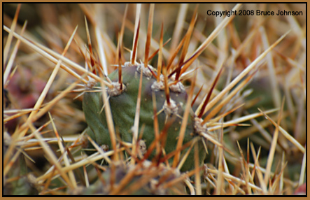
One November, I made a special trip to the area, and, indeed, found the evidence...These cacti are a tiny prickly pear cactus (opuntia fragilis). They were reported to be in some abundance by the the first white settlers to the area, so if they are not native, it is truly difficult to explain how else they got to the Sequim area! Since Sequim's average daily high temperature in even the warmest month is only 72 degrees, these must be some pretty cold-adapted cacti! My image doesn't give the viewer a sense of scale, but these are LITTLE, they struggle to get by, it is amazing to me how adaptable cacti can be (my image covers an area a bit over two inches long).
The Southern Puget Sound area is routinely wetter than the mid-Sound area around Tacoma and Seattle. What is occurring in places such as Olympia is that the typically SW track of the major storms has a direct line to Olympia, basically unimpeded by Olympic rain-shadow effects. The average for December is well over 8 inches.... Shelton, about 15 miles NW of Olympia, is even wetter, averaging about 66 inches of rain per year.
Copyright 2007-2018 by Bruce B. Johnson
OregonPhotos.com
Please Quote Author and/or obtain permission before using