Note: Much of our Hawaiian Climate Discussion is compliments of George Taylor, Past President of the American Association of State Climatologists. You may reach him at theOregon Climate Service... Here is his discussion, followed by additional notes. For information about sunburn risks in Hawaii, and on Earth in general, please click here.
George H. Taylor
(Former) State Climatologist for Oregon
Oregon State University
Corvallis, Oregon, U.S.A.
Trade Winds, Inversions, and Orographic lifting are keys to understanding Hawaiian weather:
"Trade Winds" are steady winds that blow from the east
throughout the
tropics much of the year. North of the Equator, trades generally
blow from
the northeast (in the southern hemisphere, from the southeast).
For
mariners, trades provide reliable means of transportation (at
least for
those mariners traveling by sail!). They also cause a huge influence
on
precipitation patterns in the Islands, making some tourist areas
rainy jungles.
Warm, tropical air contains very large quantities
of moisture, caused by
rapid evaporation of water from the warm ocean waters. Whenever
this warm,
humid air rises, it cools (a simple fact of atmospheric physics
that
occurs everywhere). And as air cools, its capacity for holding
water vapor
decreases. Warm air can hold a LOT more water vapor than colder
air, and
as the warm tropical air rises and cools (by about 5.5 degrees
Fahrenheit
per thousand feet), it reaches the point where it can hold no
more water
vapor. Meteorologists call this "saturation." At
that point, condensation
occurs, which means clouds form and
precipitation begins.
Orographic Lifting:
Rising air, or "uplift," can occur for a lot of reasons,
including
tropical storms. But the most sudden, and significant, reason
for air to
rise is because of the influence of topography (mountains).
Whenever tropical air
encounters mountains (on an island or on the coast of a continent),
it is
forced to rise very quickly, resulting in clouds and rain (often
very
intense rain, especially where the mountains are sudden and steep).
And
since trade winds are quite steady and reliable, the mountains
that
produce the uplift (on the east sides of the islands) are wet
and cloudy
much of the time (a wet fact not welcomed by Tourists!)
In the Hawaiian Islands, trade winds
occur well over 50% of the time
throughout the year; in some periods, this figure exceeds 90%.
Thus, the east
sides of the islands experience rainy periods much of the time.
As the rising air ascends, two things happen. First, there is
nearly aways an inversion, in Hawaii's case a "trade wind
inversion," above which the air is rather dry; usually
this
occurs at about 5,000 feet, and most of the rainfall occurs below
this
height. Second, the process of condensation is so violent and
so thorough
that by the time the air reaches this level there is generally
very little
water available anymore. The result is moderate rain at the coastline,
much heavier rain on the slopes above, and rather dry conditions
on the tallest
mountain peaks. In the Hawaiian Islands, the rainiest places
are generally
about 3,000 feet above sea level. Nights are usually wetter
than days,
because the air is cooler to begin with.
As air reaches the crest, it begins to flow
downward along the leeward
side of the peaks. As air descends, it gets warmer, and its capacity
to
hold water vapor increases. Even if new moisture is brought in
from below,
the "relative humidity" of the leeward side air is quite
low, causing the
likelihood of rainfall to be much lower than on the east side.
As a
result, leeward (west) sides of tropical islands tend to be
much drier
than windward (east) sides; ie. the Poipu Beach area is much drier
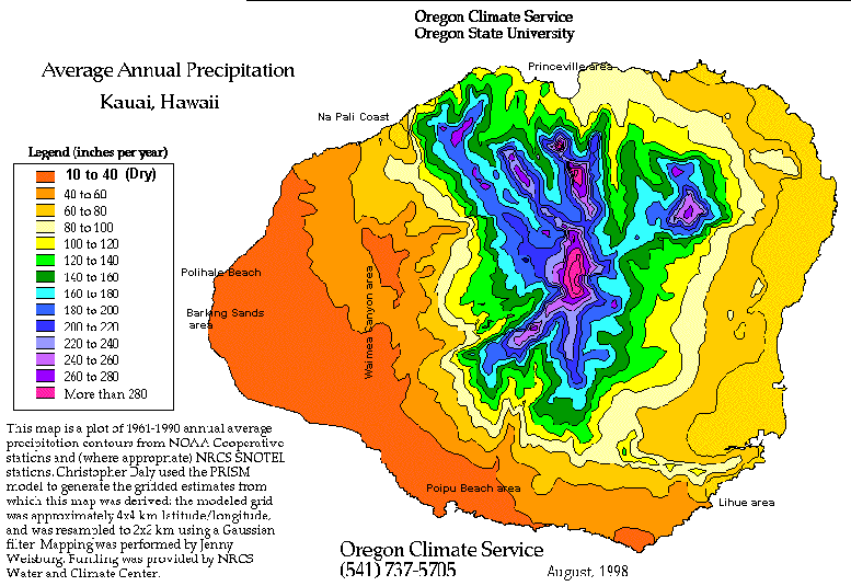
and sunnier than the Princeville area on Kauai.(See Map below).
Such weather facts are very useful for Tourists to know!
Also, the higher mountains of Hawaii, above about 6,000-8,000 feet, are arid and parched. Click below for a Big Island climate discussion, or continue down the page to read climate details about the Island of Kauai.
The island of Kauai is a deeply eroded extinct
volcano (Mount Waialeale),
and is the oldest of the major Hawaiian Islands. At its highest
point, the island
rises to about 5,000 feet, very near the typical trade wind
inversion
height. Trade winds bring clouds and rain to the eastern slopes,
with the
rain increasing dramatically at higher elevation. Lihue,
on the eastern
shore, receives about 40 inches of rain per year, heaviest in
the winter
months. But on the slopes of Waialeale, rains are much heavier
and more
frequent. In winter, about seven times as much rain falls on the
mountain
than in Lihue (43 inches in an average December, versus 6 at sea
level).
But in summer, when trade winds are steadiest, Lihue averages
about 2
inches per month and Waialeale nearly 30 inches! For the year,
Mt.
Waialeale's average is between 350 and 400 inches of precipitation.
Some
very wet years in the 1960s caused its annual average to be listed
at 460
inches at one time, which made it the wettest measured spot
on earth, but
the current "official" average is below 400. Be that
as it may, Waialeale
is one of the wettest places anywhere. The steady rain and lack
of sun
stunts the growth of the tropical vegetation, which form a full-on
rain
forest farther down the slopes.
Journey only 10 miles west, however, and
you'll be in an area of generally
clear skies, intense sun, and dry, almost desert-like weather.
Western
Kauai is a classic "rain shadow" area, with annual average
rainfall in the
12-25 inch range (in some places, even lower than that).
Few Thunderstorms:
One might expect that thunderstorms would occur frequently
on Kauai, as they do in Florida and many other tropical and subtropical
areas. However,
Lihue only receives and average of three days a year with thunderstorms.
The trade wind inversion is the biggest reason for this: thunderstorms
require deep cloud development, or "convection," and
the trade wind
inversion keeps this from happening most of the time!
Interestingly, despite Waialeale's wetness
it may not even be the wettest
spot in Hawaii, let alone the world. On Oahu's northeast side,
there are
areas that may receive more than 400 inches per year, although
there are
no rain gages to confirm this. Oregon State University's Spatial
Climate
Analysis Service is in the process of updating Hawaii's annual
precipitation map, and preliminary estimates of Oahu's mountains
suggest
tremendous rainfall.
11/14/2000: One of this site's Hawaiian readers recently noted that the Hawaiian State rainfall record for a 24 hour period occured on Kauai. This was an astonishing 38 inches during one torrential 24 hour period in 1958.
**************************************************************
Additional notes from George Taylor:
Warm tropical air contain big quantities
of moisture.
Uplift (from mountains) causes the air to cool and release
its moisture (Orographic precipitation). Since the Trade
Winds
are steady, this happens day after day, month after month,
resulting in tremendous annual rainfall totals. In fact, we suspect
that
areas in Northeast Oahu may be deluged with even more rain
than Mt. Waialeale --but there are no rain gages on that part
of Oahu.
Intense Desert in Hawaii-- read this!
Barking Sands (near Polihale Beach) gets a mere 8 inches of rainfall per year, mostly when the wind is blowing the other way (Kona Winds). This is because when air descends, it gets warmer and dries out. Thus there are huge, nearly unbelievable contrasts between wet upwind slopes of Kauai, and dry downwind areas like Waimea Canyon and Barking Sands.
Please note Update, December 2011: George Taylor has now been retired for a couple years from his longtime position as the State Climatologist, but is still active in the field privately.