Rogue
Valley under fog, with Mt Ashland beyond
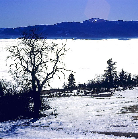
Mt Ashland, at
7,533 ft, is the high point of the Siskiyou mountains near Medford
 The Siskiyous and the
Wallowa Mountains are geologically the two most ancient ranges
in Oregon, with the Siskiyous being part of the so-called "Klamath
Knot" written about by David Rains Wallace. Both areas have unique
soil types, and are biologically exceptionally rich in diversified
flora and fauna; note the prominent oak tree in the image above,
thriving on a sunny slope at 4,200 ft.. The Medford area is unique,
possessing the vegetation types and climate more charateristic
of California than of the rest of Oregon; it is a type of climate
termed "Mediterranean" -- cool, rainy winters and hot, dry and very sunny
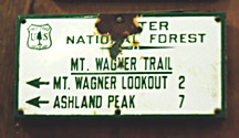
summers... The image to the left is an extremely historic trail
sign declaring "Crater National Forest," which dates
this humble sign to 1932 or earlier! The Crater NF was established
in 1908, and was renamed in 1932 into the modern "Rogue River
National Forest." The destination of "Ashland Peak"
refers to the modern "Mt. Ashland," as in my image above.
I like to imagine the view off the Mt. Wagner Lookout in those
pre-1932 times!
The Siskiyous and the
Wallowa Mountains are geologically the two most ancient ranges
in Oregon, with the Siskiyous being part of the so-called "Klamath
Knot" written about by David Rains Wallace. Both areas have unique
soil types, and are biologically exceptionally rich in diversified
flora and fauna; note the prominent oak tree in the image above,
thriving on a sunny slope at 4,200 ft.. The Medford area is unique,
possessing the vegetation types and climate more charateristic
of California than of the rest of Oregon; it is a type of climate
termed "Mediterranean" -- cool, rainy winters and hot, dry and very sunny
summers... The image to the left is an extremely historic trail
sign declaring "Crater National Forest," which dates
this humble sign to 1932 or earlier! The Crater NF was established
in 1908, and was renamed in 1932 into the modern "Rogue River
National Forest." The destination of "Ashland Peak"
refers to the modern "Mt. Ashland," as in my image above.
I like to imagine the view off the Mt. Wagner Lookout in those
pre-1932 times!
 Mt. Wagner lookout was located at the summit of 7,200 ft. Wagner
Butte, which is the pointy mountain in the center of the image.
The first permanent lookout structure went up in 1923, while 1971
saw the destruction of the mountain's final lookout structure....
In the 1960s, Wagner was a rigorous hike on a old trail that was
something of a challenge to follow. It's summit was a spectacular
vantage point by daylight, but at night my high school friends
and I managed to scare ourselves silly with readings from Edgar
Alan Poe! The lookout has been torn down and defunct for several
decades. Click
here for a hiking story
which takes place at a lake reached by hiking nine miles SE along
the ridge from which this picture was taken.
Mt. Wagner lookout was located at the summit of 7,200 ft. Wagner
Butte, which is the pointy mountain in the center of the image.
The first permanent lookout structure went up in 1923, while 1971
saw the destruction of the mountain's final lookout structure....
In the 1960s, Wagner was a rigorous hike on a old trail that was
something of a challenge to follow. It's summit was a spectacular
vantage point by daylight, but at night my high school friends
and I managed to scare ourselves silly with readings from Edgar
Alan Poe! The lookout has been torn down and defunct for several
decades. Click
here for a hiking story
which takes place at a lake reached by hiking nine miles SE along
the ridge from which this picture was taken.
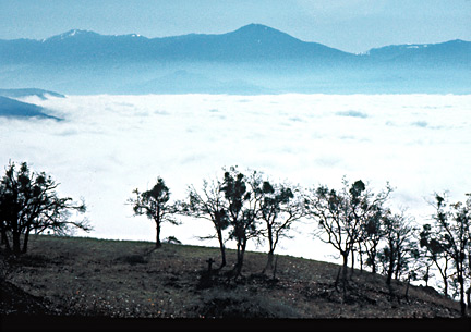
Mt Ashland has
for many years been home of Oregon's southernmost Ski area, simply
called Mt. Ashland Ski Area. It's where this photographer first
experimented with downhill skiing, borrowing his brother's Head
skis. Of course, his new Konica 35mm SLR camera came along, and
took these pictures .... If one turns and faces northwest from
this spot on a day without fog, they can also see one of the Rogue
Valley's well-known landmarks-- Upper and Lower "Table Rock,"
which are prominent dry mesas lying a mile north of the Roger
River...... Oregon's other major ski areas lie far to the north
of the Siskiyous (Timberline Ski Area, Mt. Bachelor Ski Area,
Mt. Hood Meadows).... a lesser-known area, Anthony Lakes Ski Area,
lies in the Blue Mountains of NE Oregon, very far to the east
of the Cascade Mountains--- like Mt. Ashland, Anthony Lakes is
far from any major urban area; also like Mt. Ashland, it's base
elevation is very high (7,100 ft), even higher than Mt. Ashland's
base (6,380 ft.).
View
south into California from the summit chair of Mt. Ashland
It's hard to
imagine from up here in the brillant sky, but it's another bitterly
dank and dark foggy day all over the populated areas of the Rogue
Valley, Medford, Ashland, and Northern California. This kind of
day made it difficult for the Young Photographer to want to rejoin
his family in their dim Valley Home. He began to long to stay
high in the mountains and leave behind his youth.
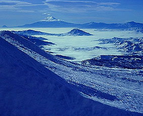
Mt Shasta, one
of the great giants of the Cascade Range, beckons impressively
in the distance, some 55 miles away. The photographer was to attain
its rarified peak 3 years later, after suffering mightily with
his first bout of altitude sickness--- take a look on the "Meet
your Photographer" page, near the bottom, and you'll see
him, outwardly jubilant, but inwardly Dueling with a headache
and incipient nausea as he gropes his way across a field of Neve'
Penitente snow spikes.
page
last revised 10/16/2025
Dark
Lake of My Dreams
Our goal was
to visit a place not shown on any map and make it ours. My high
school friends John and Greg and I poured over our USGS topo maps,
and found a small lake in the mountains east of Medford. We decided
then and there, "This is it!" Maybe we missed the irony
of our method, but truly, in this modern era of aerial and satellite
mapping, a place like a lake, however small, isn't going to escape
the mapmakers pen, and if it is year-round water and even 1/4
mile long, it will have a name.... But our chosen lake at least
had no road or trail leading to it... And it lay in the bottom
of a deep canyon which was heavily forested, which suited our
imaginations well because it meant that the only way to its unknown
shores was via bushwacking up or down the steep canyon.
After a dusty
ride, John's parents dropped us off in the headwaters area about
1,200 ft. above the lake. We figured it was about 3 miles down
to our target. After a pleasant meadow, we entered a steepening
canyon with dense vegetation, and soon our frame packs proved
to be highly annoying as they repeatedly snagged on the vine maple
and understory trees, but we persisted downward, youthful and
strong. We had been planning a week-long backpack in the High
Cascades, but it was still snowed-in up there at over 6,000 ft,
so we thought we'd warm up for The Big One by hiking to this 3,600
ft. high place in the lower regions of the Cascades.
In mid-afternoon,
covered with sweat and scratches, we stumbled out onto the lake
shore. We had found it! Our eyes took in a dim scene, still, quiet,
seemingly a Lost World. Our high school English class had forced
us to read "Lord of the Flies," and now, suddenly, WE
were them! Civilization was vanished and was no more. We were
alone for three days to create and destroy, and that we did with
a vengeance. A modest stream entered the lake, and there at virtually
the only flat spot along the entire lakeshore, we set up camp
and campfire. The stream had created a small delta of pebbles
and gravel, which was one of the few places open enough to the
sky that we could warm ourselves with sunshine for a few hours
each day.
After a quiet
night, morning found us spread all over the delta. We began to
imagine a mighty dam. We had no drills or bulldozers, only our
adolescent strength, but by noontime all manner of levers and
pry bars littered the delta as we strained and rolled and pushed
any heavy object we could find, mostly stones and dead trees from
along the shore. Timber-falling beckoned to us, but with only
a hacket, it defied our abilities. Not that we didn't try.
By the second
day of hard labor, our dam was leaking in dozens of places, but
had created a pond some 20 inches deep and 12 feet long. By the
third day we had pushed waters 30 feet upstream behind a 3 feet
high dam by the use of many more big rocks and much caulking.
We had paused
that afternoon from our labors. It was quiet at the lake once
more, and our arguments about construction details seemed at peace.
A sense that our time at No Name Lake was nearly over laid upon
us. I was opening a package of cheese when without warning one
of our largest boulders fell off the dam. Swiftly our hard-won
waters began to pour out through the gap. Before we could even
get to the break, two more of our larger rocks had also been pushed
aside. We stood in the chilly water above the dam as the creek
rapidly carved its way nearly back to base level. For a few moments,
we seemed poised at a choice. We could scream in anger, or we
could joyously cheer the rushing waters. We cheered. We gave the
lake back to itself and departed, reaching our pick-up point in
near-darkness.
*************************************************************************************
Factual Details:
first, a note of caution-- parts of this journey may be on private
land; I did not have a current Rogue River National Forest map
on hand with which to check this out (in recent decades government
agencies have done a lot of land trading and so an old map or
a USGS topo will not answer the question of private vs. public).
The Lake in my
story is Lost Lake, elev. 3,590, and it is on Lost Creek! The
lake is 1/4 mile long and fairly skinny. The nearest road is a
very primitive one that deadends about 230 vertical ft. above
the lake's NW shore (then you get to bushwack down to the lake,
and then bushwack clean around the lake trying to find a flat
spot to camp).... 0.9 miles upstream at 4,060 ft are a nice falls.
Lost Creek's headwaters lie along the high country just east of
Grizzly, the peak of which is 5,920 ft. This high country has
many minor peaks just above 5,000 ft.... 3.5 miles to the SW by
air is the old Shale City mine (4,480 ft), which actually is on
the opposite side of the watershed divide from Lost Creek.....
The peak of Grizzly is 4.3 air miles from Lost Lake.
Downstream, it is about 5.5 river miles to the junction with Butte
Creek at 1,840 ft. and a hot lowland Rogue Valley climate. (average
drop is a steep 320 feet per mile)
Upstream, go past the falls, take the SW branch and keep going,
at about 2.3 miles from the lake, you reach a nice meadow at 4,540
ft. Go upstream from there about another 0.6 miles and you reach
a more major dirt road at 4,840 ft, which is really right at the
headwaters of this branch of Lost Creek.... This is probably where
we got dropped off for our hike by John's parents. (2.9 miles
downhill to the lake, an average drop of 430 ft. per mile). The
total length of Lost Creek is therefore only about 8.5 miles.
Note: there are many little lakes about 3.6 miles south of Lost
Lake; they are smaller than Lost Lake and truly are unnamed. 4WD
primitive roads snake thru them; elevations are about 4,600 to
4,975 ft. The ridge above them rises to a max. of 5,450 ft, and
there is a more major dirt road along the ridgetop..... None of
these lakes have outlet streams, but they are more or less on
the headwaters of Babe Creek, with Ice House Lake at 3,800 ft
being 1.6 river miles downstream from the lakes. Babe Creek becomes
Frog Creek, which then empties into Walker Creek at 2,200 ft.,
then it is only 0.9 miles to paved
road at 2,080 ft. beside
the creek. Then go another 1.9 miles downstream and meet the junction
of big Emigrant Creek and the Ashland Municipal Airport,
Sumner Parker Field at 1,860 ft, and you are truly now in the
Rogue River Valley lowlands!
Copyright, 2007-2026
by Bruce B. Johnson MA
All Rights Reserved