In late September/early October of 2014, Ranger J. Thomas Jeffrey and I again collaborated to successfully find the route of the Summit Trail, from Rockpile Lake to The Tree (where a giant hemlock tree marked the historic junction of the Brush Creek Trail (BCT) and the Summit Trail; this junction was a place that I had found and photographed in 1973).
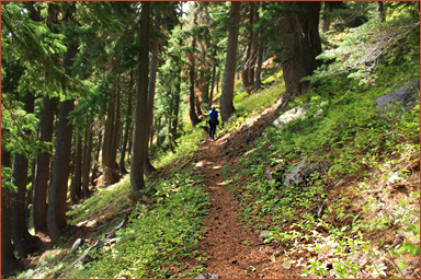
BCT: in September, Ranger Thomas hiked up from the original trailhead of the BCT, reaching The Tree and continuing up to the Cascade Crest, then dropping down to Carl Lake and exiting back to his car via the Carl Lake/Shirley Lake Trail..... Below is a picture he took of his companion hiking on the original trail tread of the BCT. This was just a bit west (1/4 mile) of the scenic rocky divide that has always been a barrier to horses using the BCT. This picture is well under a mile east of The Tree. It's truly amazing that the original trail tread shows so well despite at least 40 years without any maintenance! This section of trail is on a south-facing slope at 6000 ft. elevation. As you can see, the 2003 B&B Fire did not touch this section of the BCT.
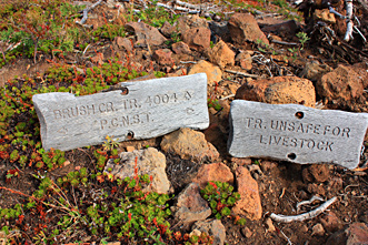
The original BCT was "rehabed" sometime after 1982 and before the B&B Fire hit the area in 2003.... This rehab greatly affected the upper part of the BCT---- the Summit Trail No. 65 was abandoned, seemingly as part of the opening of the modern PCT along the crest..... As part of this trail work, the upper part of the BCT was re-routed and re-signed, by-passing THE TREE, and now joining the PCT about 0.4 miles north of Rockpile Lake. (the Summit Trail going from THE TREE directly south to Rockpile Lake was abandoned, as was the portion going up from THE TREE to the ridgetop at the South Cinder Peak saddle).... .All images compliments of Ranger Jeffrey 2010-2014. Latest update: Sept. 2014. Ranger Jeffrey hiked the trails again, and once again found these two wooden signs where the modern version of the BCT joined with the PCT. The signs were still in good shape, but lying on the ground, so he propped them up at an appropriate location.
BCT, version three: 2003 to present--
apparently, the BCT is now on the "endangered trails"
list-- not maintained, in danger of fading into history for good.....
In the 2010 picture below, the photographer was standing
on the PCT, about 0.4 miles north of Rockpile Lake. At that time,
there was a rough cairn of rocks that held up the "pole"
that in better days had the Brush Creek sign bolted onto it. In
2010, the sign laid at the base of the pole, and had been lying
there for at least three years. 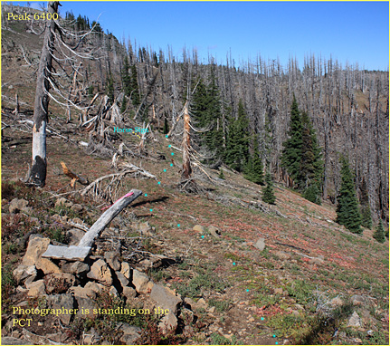 At
the top of the pole someone had attached a strip of orange marking
tape. The tip of the pole pointed downhill to the northeast, where
the BCT ascended to meet the PCT. If you follow the aqua dots
I have added to mark the old trail tread, you see some text I
added. This is the "Trail Unsafe for Livestock" sign
seen in image above; it is about 100 yards downhill from the PCT.
The main reason the trail is unsafe for horses is really not due
to anything about the B&B fire damage and debris. The trail
was unsafe even before the B&B Fire of 2003, and that is due
to one short section of the BCT about 1.5 miles north of this
junction. It's a very steep, narrow, rocky place where the BCT
ascends to a small saddle as it heads east along the 6200 foot
high crest of the Brush Creek Ridge. This saddle is VERY SCENIC
and highly recommended, with great views both north toward Carl
Lake and Mt. Jefferson, and south toward Three-Fingered Jack and
beyond.
At
the top of the pole someone had attached a strip of orange marking
tape. The tip of the pole pointed downhill to the northeast, where
the BCT ascended to meet the PCT. If you follow the aqua dots
I have added to mark the old trail tread, you see some text I
added. This is the "Trail Unsafe for Livestock" sign
seen in image above; it is about 100 yards downhill from the PCT.
The main reason the trail is unsafe for horses is really not due
to anything about the B&B fire damage and debris. The trail
was unsafe even before the B&B Fire of 2003, and that is due
to one short section of the BCT about 1.5 miles north of this
junction. It's a very steep, narrow, rocky place where the BCT
ascends to a small saddle as it heads east along the 6200 foot
high crest of the Brush Creek Ridge. This saddle is VERY SCENIC
and highly recommended, with great views both north toward Carl
Lake and Mt. Jefferson, and south toward Three-Fingered Jack and
beyond.
First Picture below: the trail tread
of the old Summit Trail, Oct. 3, 2014. This is on the wooded slopes
right below the north end of Rockpile Lake. Even after at least
45 years of no maintenance, the tread remains obvious in places!
As you can see, the 2003 B&B Fire missed the area immediately
around Rockpile Lake.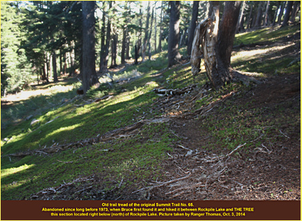
In history, the first version of the Summit Trail was perhaps in existence as early as the original blazed Oregon Skyline Trail of 1921 (eg., the section of the Summit Trail from Rockpile Lake northward a few miles may have coincided with the actual route of the original Oregon Skyline Trail, as shown on the 1921 map of the same name).
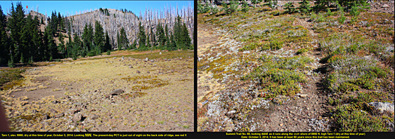
Summit Trail, second version: 1931 to unkn, estimate the 1950s, this was the major access route to the entire area from .?. to..?. , before the modern PCT was completed circa 1974. On some old maps, this version of the trail may have been named "the Little Lake Trail." In the picture collage below, Ranger Thomas found another piece of the old trail tread beside a small tarn that we call "Tarn 1." This is the shallowest of the three tarns and by late summer is nothing but a dry meadow. The old tread is along its southern shoreline. Tarn 1 is at 5990 feet elevation. The modern PCT runs along the ridgetop in the background, but about 200 feet higher and out of sight as it runs on the west side of the ridge. It would be easy to drop down to Tarn 1 from the PCT..... (Note: we have many more pictures and graphics which could be shared (brucej@Oregonphotos.com, if contacted).
Summit Trail, version three, this version carried the official trail number of #65... Its route was much like version two, but parts rerouted, and of special note, much-lengthed at its Northern end to access Hole in the Wall Park. The origin of that unique place name is brimming with colorful Old West history, the "Hole in the Wall Gang," a loosely knit confederation of outlaw gangs that used a place in the mountains of Wyoming (Johnson County) for some 40-50 years, an easily defended "Hole" that was their impenetrable stronghold, never successfully breached by lawmen. The famed Butch Cassidy had a cabin here, which is now on display in Cody, Wyoming! The Sundance Kid was also affiliated. Thus, Oregon's deep Hole must have reminded someone of an impenetrable spot for a great outlaw hide-out.
The Skyline Trail: 1921 to unkn. At some point, the name was changed, to "Oregon Skyline Trail No. 2000." It had also undergone several major reroutings.
The Oregon Skyline Trail No. 2000
The modern PCT, circa 1973 to the present. (apparently not re-routed in this region, although it has suffered various stages of disrepair since the 2003 B&B Fire).
For further exploration is the old John Swallow Trail which takes off from the PCT and runs along the south side of South Cinder Peak, leading to Swallow Lake, and then downward a couple miles to the "John Swallow Grave," (is there really an old grave there?)....then downward another couple miles to Marion Lake. Before the modern PCT came into existence, one could hike up the Brush Creek Trail No. 69 to BIG TREE junction, where then you'd follow trail #65 uphill a short distance to the crest of the Cascades. There, you would meet the John Swallow Trail No. 3488 and descend, as just decribed, to Marion Lake. In the old days, a road went to the lake (elev. 4,100 ft). There was a FS Guard Station, and cabins there, some probably for rent in the summertimes. What a great connection route this was between the Camp Sherman/Metolious area and the Marion Lake area on the west side of the Cascades!
--- by Bruce B. Johnson M.A., August 21, 2015, reviewed 1/14/2023