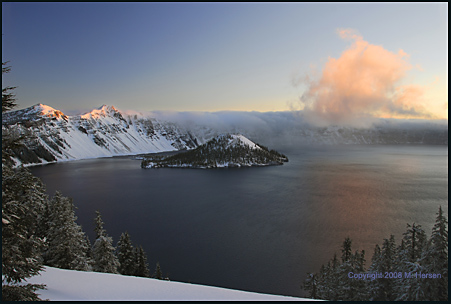
On this page I present two treasures. First, the work of Michel Hersen, a friend of mine with a sense of vision that swiftly brings me to that sense of magic in Nature. Michel has impressive academic credentials in Fine Arts, and that training is everywhere evident in the color and composition of his work. He and I have discussed offering his work for sale here; if interested, please contact me.
The second
teasure is a glimpse of a bygone era at Crater Lake Park. The year is 1931, the US is falling hard
into the grips of the Great Depression. Television was far away
in the future, and even radio was just making its presence common
in American homes. The map shows the southern terminus of the
historic Oregon Skyline Trail (red dotted line). 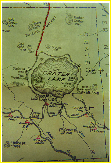 The
Skyline Trail was the rough-and-ready predecessor to the modern
Pacific Crest National Scenic Trail. One interesting feature of
the Trail in 1931 is an unlikely coincidence of names. The northern
end of the Trail at that time was the town of "Government
Camp" on Mt. Hood's southern slopes, while near the southern
end of the Trail is seen what appears to be a Park campground
by the same name! Other images from the 1931 map can be seen at
this link: 1931 Trail Map.
The
Skyline Trail was the rough-and-ready predecessor to the modern
Pacific Crest National Scenic Trail. One interesting feature of
the Trail in 1931 is an unlikely coincidence of names. The northern
end of the Trail at that time was the town of "Government
Camp" on Mt. Hood's southern slopes, while near the southern
end of the Trail is seen what appears to be a Park campground
by the same name! Other images from the 1931 map can be seen at
this link: 1931 Trail Map.